Jega geodata
Jega (Kebbi) is a seat of a second-order administrative division; located in Nigeria in Africa/Lagos (GMT+1) time zone. With population of 73,495 people, there are 126 cities with bigger population in this country. Compared to other cities in Nigeria, 87% of cities are located further ↓South; 88.8% of cities are located further →East and 55.6% of cities have higher elevation than Jega. Note1


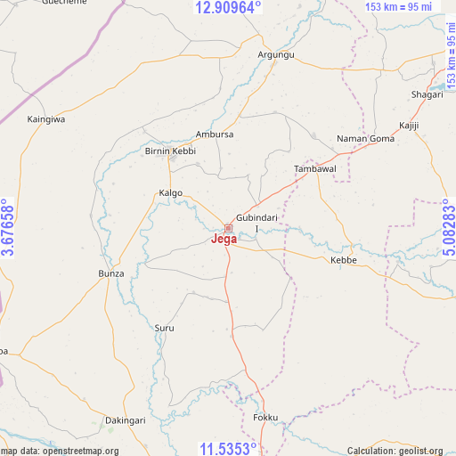
Jega GPS coordinates[2]
12° 13' 24.096" North, 4° 22' 46.956" East
| Map corner | latitude | longitude |
|---|---|---|
| Upper-left | 12.90964°, | 3.67658° |
| Center: | 12.22336°, | 4.37971° |
| Lower-right: | 11.5353°, | 5.08283° |
| Map W x H: | 152.8×152.8 km | = 94.9×94.9mi |
| max Lat: | 13.7543° ⇑13% North |
| Jega: | 12.22336° |
| min Lat: | ⇓87% South 4.31231° |
| min Long | Jega | max Long |
| 2.73333° | 4.37971° | 14.46552° |
| W 11.2%⇐ | ⇒88.8% E |
Elevation
Elevation of Jega is 242 m = 794 ft, and this is 54.5 m = 179 ft below average elevation for this country.
| Max E: |
1599 m = 5246 ft | 55.6% |
| Avg. | 296.5 m = 973 ft | |
| Jega | 242 m = 794 ft | |
Min E: |
2 m = 7 ft | 44.4% |
See also: Jega elevation on elevation.city.
Geographical zone
Jega is located in North Torrid zone (between Equator and Tropic of Cancer). Distance of this Northern Tropic circle is 1246.8 km =774.7 mi to North.| Distance of | km | miles | from Jega |
|---|---|---|---|
| North Pole | 8648 | 5373.6 | to North |
| Arctic Circle | 6042.1 | 3754.4 | to North |
| Tropic Cancer | 1246.8 | 774.7 | to North |
| Equator | 1359.1 | 844.5 | to South |


Nearby cities:
15 places around Jega: (largest is in red/bold)
• Aliero
12.3 km =7.6 mi,  54°
54°
• Argungu
60.1 km =37.3 mi,  15°
15°
• Augie
77.9 km =48.4 mi, 17°
• Birnin Kebbi
32.4 km =20.1 mi,  322°
322°
• Bunza
42.4 km =26.3 mi,  249°
249°
• Dakingari
72.7 km =45.2 mi,  208°
208°
• Gulma
46.7 km =29 mi,  356°
356°
• Gwandu
42.2 km =26.2 mi,  42°
42°
• Kalgo
22.6 km =14 mi,  300°
300°
• Kangiwa
71.2 km =44.2 mi, 301°
• Kebbe
40 km =24.9 mi,  105°
105°
• Kende
79.3 km =49.3 mi,  189°
189°
• Maiyama
15.7 km =9.8 mi,  184°
184°
• Shagari
80.3 km =49.9 mi,  56°
56°
• Tambuwal
35.3 km =21.9 mi, 54°
Sources, notices
• [Note1] Compared only with cities in Nigeria existing in our database
• [Src1] Map data: © OpenStreetMap contributors (CC-BY-SA)
• [Src2] Other city data from geonames.org with taken over terms of usage.
• [Src3] Geographical zone / Annual Mean Temperature by Robert A. Rohde @ Wikipedia
