Mahuta geodata
Mahuta (Kebbi) is a seat of a second-order administrative division; located in Nigeria in Africa/Lagos (GMT+1) time zone. With population of 9,047 people, there are 356 cities with bigger population in this country. Compared to other cities in Nigeria, 78.6% of cities are located further ↓South; 81.7% of cities are located further →East and 51.9% of cities have higher elevation than Mahuta. Note1


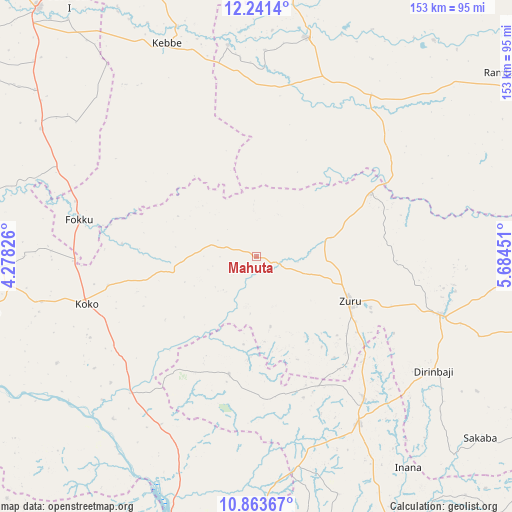
Mahuta GPS coordinates[2]
11° 33' 12.168" North, 4° 58' 52.968" East
| Map corner | latitude | longitude |
|---|---|---|
| Upper-left | 12.2414°, | 4.27826° |
| Center: | 11.55338°, | 4.98138° |
| Lower-right: | 10.86367°, | 5.68451° |
| Map W x H: | 153.2×153.2 km | = 95.2×95.2mi |
| max Lat: | 13.7543° ⇑21.4% North |
| Mahuta: | 11.55338° |
| min Lat: | ⇓78.6% South 4.31231° |
| min Long | Mahuta | max Long |
| 2.73333° | 4.98138° | 14.46552° |
| W 18.3%⇐ | ⇒81.7% E |
Elevation
Elevation of Mahuta is 271 m = 889 ft, and this is 25.5 m = 84 ft below average elevation for this country.
| Max E: |
1599 m = 5246 ft | 51.9% |
| Avg. | 296.5 m = 973 ft | |
| Mahuta | 271 m = 889 ft | |
Min E: |
2 m = 7 ft | 48.1% |
See also: Nigeria elevation on elevation.city.
Geographical zone
Mahuta is located in North Torrid zone (between Equator and Tropic of Cancer). Distance of Equator is 1284.6 km =798.2 mi to South.| Distance of | km | miles | from Mahuta |
|---|---|---|---|
| North Pole | 8722.4 | 5419.8 | to North |
| Arctic Circle | 6116.6 | 3800.7 | to North |
| Tropic Cancer | 1321.3 | 821 | to North |
| Equator | 1284.6 | 798.2 | to South |


Nearby cities:
15 places around Mahuta: (largest is in red/bold)
• Bagudo
84 km =52.2 mi,  258°
258°
• Besse
67.9 km =42.2 mi,  242°
242°
• Bin Yauri
87.7 km =54.5 mi,  192°
192°
• Bukkuyum
83.8 km =52.1 mi,  39°
39°
• Dabai
25.9 km =16.1 mi,  109°
109°
• Duku
36.2 km =22.5 mi, 192°
• Gummi
67.4 km =41.9 mi,  12°
12°
• Kebbe
69.4 km =43.1 mi,  337°
337°
• Kende
78.6 km =48.8 mi,  267°
267°
• Ribah
57.7 km =35.9 mi, 107°
• Rijau
58.2 km =36.2 mi,  149°
149°
• Sakaba
86.3 km =53.6 mi,  129°
129°
• Shanga
57.8 km =35.9 mi,  229°
229°
• Yelwa
84 km =52.2 mi,  198°
198°
• Zuru
30.6 km =19 mi,  115°
115°
Sources, notices
• [Note1] Compared only with cities in Nigeria existing in our database
• [Src1] Map data: © OpenStreetMap contributors (CC-BY-SA)
• [Src2] Other city data from geonames.org with taken over terms of usage.
• [Src3] Geographical zone / Annual Mean Temperature by Robert A. Rohde @ Wikipedia
