Tambuwal geodata
Tambuwal (Sokoto) is a seat of a second-order administrative division; located in Nigeria in Africa/Lagos (GMT+1) time zone. With population of 20,932 people, there are 197 cities with bigger population in this country. Compared to other cities in Nigeria, 89.3% of cities are located further ↓South; 86.1% of cities are located further →East and 53.1% of cities have higher elevation than Tambuwal. Note1


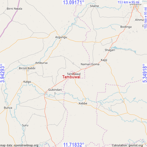
Tambuwal GPS coordinates[2]
12° 24' 21.312" North, 4° 38' 45.78" East
| Map corner | latitude | longitude |
|---|---|---|
| Upper-left | 13.09171°, | 3.94293° |
| Center: | 12.40592°, | 4.64605° |
| Lower-right: | 11.71832°, | 5.34918° |
| Map W x H: | 152.7×152.7 km | = 94.9×94.9mi |
| max Lat: | 13.7543° ⇑10.7% North |
| Tambuwal: | 12.40592° |
| min Lat: | ⇓89.3% South 4.31231° |
| min Long | Tambuwal | max Long |
| 2.73333° | 4.64605° | 14.46552° |
| W 13.9%⇐ | ⇒86.1% E |
Elevation
Elevation of Tambuwal is 261 m = 856 ft, and this is 35.5 m = 116 ft below average elevation for this country.
| Max E: |
1599 m = 5246 ft | 53.1% |
| Avg. | 296.5 m = 973 ft | |
| Tambuwal | 261 m = 856 ft | |
Min E: |
2 m = 7 ft | 46.9% |
See also: Nigeria elevation on elevation.city.
Geographical zone
Tambuwal is located in North Torrid zone (between Equator and Tropic of Cancer). Distance of this Northern Tropic circle is 1226.5 km =762.1 mi to North.| Distance of | km | miles | from Tambuwal |
|---|---|---|---|
| North Pole | 8627.7 | 5361 | to North |
| Arctic Circle | 6021.8 | 3741.8 | to North |
| Tropic Cancer | 1226.5 | 762.1 | to North |
| Equator | 1379.4 | 857.1 | to South |


Nearby cities:
15 places around Tambuwal: (largest is in red/bold)
• Aliero
23 km =14.3 mi,  235°
235°
• Argungu
39.9 km =24.8 mi,  340°
340°
• Augie
54.1 km =33.6 mi,  354°
354°
• Birnin Kebbi
49 km =30.4 mi,  276°
276°
• Bodinga
73.2 km =45.5 mi,  48°
48°
• Gulma
41.1 km =25.5 mi,  309°
309°
• Gummi
58.9 km =36.6 mi,  119°
119°
• Gwandu
10.7 km =6.6 mi,  358°
358°
• Jega
35.3 km =21.9 mi,  234°
234°
• Kalgo
49.2 km =30.6 mi,  259°
259°
• Kebbe
32.3 km =20.1 mi,  162°
162°
• Maiyama
46.9 km =29.1 mi,  219°
219°
• Shagari
45 km =28 mi,  56°
56°
• Silame
73.7 km =45.8 mi,  17°
17°
• Yabo
53.2 km =33.1 mi, 48°
Sources, notices
• [Note1] Compared only with cities in Nigeria existing in our database
• [Src1] Map data: © OpenStreetMap contributors (CC-BY-SA)
• [Src2] Other city data from geonames.org with taken over terms of usage.
• [Src3] Geographical zone / Annual Mean Temperature by Robert A. Rohde @ Wikipedia
