Gaya geodata
Gaya (Kano) is a seat of a second-order administrative division; located in Nigeria in Africa/Lagos (GMT+1) time zone. With population of 20,959 people, there are 196 cities with bigger population in this country. Compared to other cities in Nigeria, 82.9% of cities are located further ↓South; 76.7% of cities are located further ←West and 75.8% of cities have lower elevation than Gaya. Note1


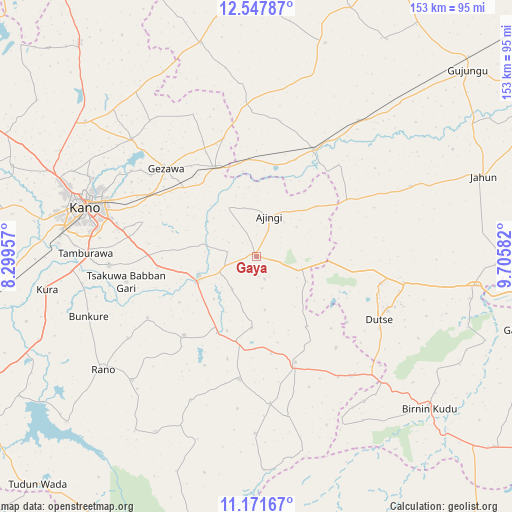
Gaya GPS coordinates[2]
11° 51' 38.304" North, 9° 0' 9.72" East
| Map corner | latitude | longitude |
|---|---|---|
| Upper-left | 12.54787°, | 8.29957° |
| Center: | 11.86064°, | 9.0027° |
| Lower-right: | 11.17167°, | 9.70582° |
| Map W x H: | 153×153 km | = 95.1×95.1mi |
| max Lat: | 13.7543° ⇑17.1% North |
| Gaya: | 11.86064° |
| min Lat: | ⇓82.9% South 4.31231° |
| min Long | Gaya | max Long |
| 2.73333° | 9.0027° | 14.46552° |
| W 76.7%⇐ | ⇒23.3% E |
Elevation
Elevation of Gaya is 437 m = 1434 ft, and this is 140.5 m = 461 ft above average elevation for this country.
| Max E: |
1599 m = 5246 ft | 24.2% |
| Gaya | 437 m 1434 ft | |
| Avg. | 296.5 m = 973 ft | |
Min E: |
2 m = 7 ft | 75.8% |
See also: Nigeria elevation on elevation.city.
Geographical zone
Gaya is located in North Torrid zone (between Equator and Tropic of Cancer). Distance of this Northern Tropic circle is 1287.1 km =799.8 mi to North.| Distance of | km | miles | from Gaya |
|---|---|---|---|
| North Pole | 8688.3 | 5398.7 | to North |
| Arctic Circle | 6082.4 | 3779.4 | to North |
| Tropic Cancer | 1287.1 | 799.8 | to North |
| Equator | 1318.8 | 819.5 | to South |


Nearby cities:
15 places around Gaya: (largest is in red/bold)
• Ajingi
12.5 km =7.8 mi,  17°
17°
• Albasu
25.6 km =15.9 mi,  144°
144°
• Dawakin Kudu
44.2 km =27.5 mi,  266°
266°
• Dutse
38.4 km =23.9 mi,  107°
107°
• Garko
32 km =19.9 mi,  222°
222°
• Gezawa
38.4 km =23.9 mi,  314°
314°
• Kibiya
52.5 km =32.6 mi,  225°
225°
• Minjibir
51.5 km =32 mi, 313°
• Ringim
36.7 km =22.8 mi,  28°
28°
• Sumaila
37.1 km =23.1 mi,  187°
187°
• Takai
33.7 km =20.9 mi,  159°
159°
• Taura
50.9 km =31.6 mi,  36°
36°
• Warawa
32.8 km =20.4 mi, 271°
• Wudil
18.2 km =11.3 mi,  251°
251°
• Zakirai
29.6 km =18.4 mi,  334°
334°
Sources, notices
• [Note1] Compared only with cities in Nigeria existing in our database
• [Src1] Map data: © OpenStreetMap contributors (CC-BY-SA)
• [Src2] Other city data from geonames.org with taken over terms of usage.
• [Src3] Geographical zone / Annual Mean Temperature by Robert A. Rohde @ Wikipedia
