Dutse geodata
Dutse (Jigawa) is a seat of a first-order administrative division; located in Nigeria in Africa/Lagos (GMT+1) time zone. With population of 17,129 people, there are 218 cities with bigger population in this country. Compared to other cities in Nigeria, 81.2% of cities are located further ↓South; 79.4% of cities are located further ←West and 77% of cities have lower elevation than Dutse. Note1


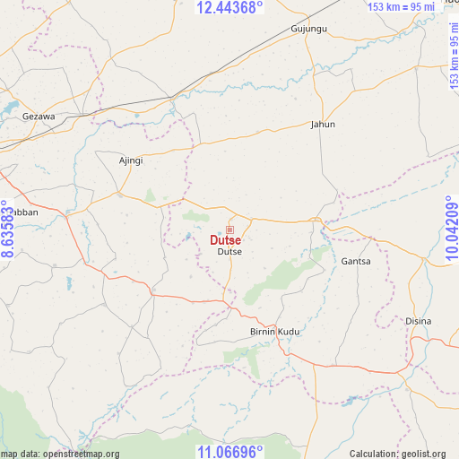
Dutse GPS coordinates[2]
11° 45' 22.248" North, 9° 20' 20.256" East
| Map corner | latitude | longitude |
|---|---|---|
| Upper-left | 12.44368°, | 8.63583° |
| Center: | 11.75618°, | 9.33896° |
| Lower-right: | 11.06696°, | 10.04209° |
| Map W x H: | 153.1×153.1 km | = 95.1×95.1mi |
| max Lat: | 13.7543° ⇑18.8% North |
| Dutse: | 11.75618° |
| min Lat: | ⇓81.2% South 4.31231° |
| min Long | Dutse | max Long |
| 2.73333° | 9.33896° | 14.46552° |
| W 79.4%⇐ | ⇒20.6% E |
Elevation
Elevation of Dutse is 444 m = 1457 ft, and this is 147.5 m = 484 ft above average elevation for this country.
| Max E: |
1599 m = 5246 ft | 23% |
| Dutse | 444 m 1457 ft | |
| Avg. | 296.5 m = 973 ft | |
Min E: |
2 m = 7 ft | 77% |
See also: Nigeria elevation on elevation.city.
Geographical zone
Dutse is located in North Torrid zone (between Equator and Tropic of Cancer). Distance of this Northern Tropic circle is 1298.8 km =807 mi to North.| Distance of | km | miles | from Dutse |
|---|---|---|---|
| North Pole | 8699.9 | 5405.9 | to North |
| Arctic Circle | 6094 | 3786.6 | to North |
| Tropic Cancer | 1298.8 | 807 | to North |
| Equator | 1307.2 | 812.3 | to South |


Nearby cities:
15 places around Dutse: (largest is in red/bold)
• Ajingi
40.5 km =25.2 mi,  305°
305°
• Albasu
23.4 km =14.5 mi,  247°
247°
• Birnin Kudu
37.1 km =23.1 mi,  155°
155°
• Gantsa
43.4 km =27 mi,  103°
103°
• Garko
59.5 km =37 mi,  258°
258°
• Gaya
38.4 km =23.9 mi,  287°
287°
• Jahun
47.5 km =29.5 mi,  41°
41°
• Kiyawa
29.3 km =18.2 mi,  83°
83°
• Ringim
48 km =29.8 mi,  336°
336°
• Samamiya
55.9 km =34.7 mi,  144°
144°
• Sumaila
48.7 km =30.3 mi,  238°
238°
• Takai
32.1 km =19.9 mi,  231°
231°
• Taura
52.7 km =32.7 mi,  353°
353°
• Wudil
54.2 km =33.7 mi,  276°
276°
• Zakirai
62.5 km =38.8 mi, 307°
Sources, notices
• [Note1] Compared only with cities in Nigeria existing in our database
• [Src1] Map data: © OpenStreetMap contributors (CC-BY-SA)
• [Src2] Other city data from geonames.org with taken over terms of usage.
• [Src3] Geographical zone / Annual Mean Temperature by Robert A. Rohde @ Wikipedia
