Taura geodata
Taura (Jigawa) is a seat of a second-order administrative division; located in Nigeria in Africa/Lagos (GMT+1) time zone. In our database, there are 451 cities with bigger population. Compared to other cities in Nigeria, 87.1% of cities are located further ↓South; 79.1% of cities are located further ←West and 67.8% of cities have lower elevation than Taura. Note1


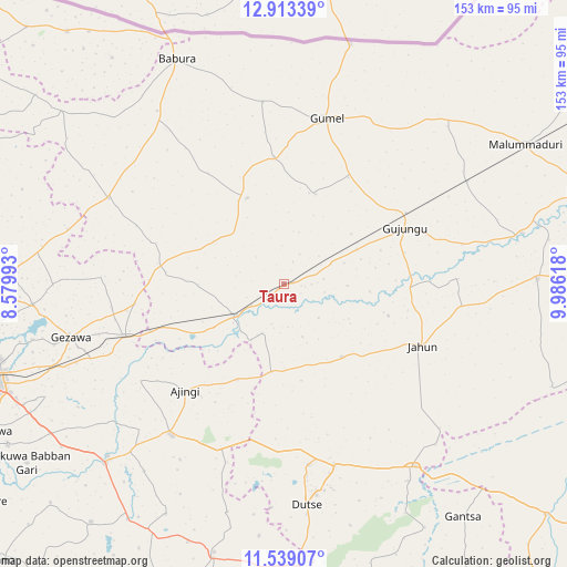
Taura GPS coordinates[2]
12° 13' 37.632" North, 9° 16' 59.016" East
| Map corner | latitude | longitude |
|---|---|---|
| Upper-left | 12.91339°, | 8.57993° |
| Center: | 12.22712°, | 9.28306° |
| Lower-right: | 11.53907°, | 9.98618° |
| Map W x H: | 152.8×152.8 km | = 94.9×94.9mi |
| max Lat: | 13.7543° ⇑12.9% North |
| Taura: | 12.22712° |
| min Lat: | ⇓87.1% South 4.31231° |
| min Long | Taura | max Long |
| 2.73333° | 9.28306° | 14.46552° |
| W 79.1%⇐ | ⇒20.9% E |
Elevation
Elevation of Taura is 384 m = 1260 ft, and this is 87.5 m = 287 ft above average elevation for this country.
| Max E: |
1599 m = 5246 ft | 32.2% |
| Taura | 384 m 1260 ft | |
| Avg. | 296.5 m = 973 ft | |
Min E: |
2 m = 7 ft | 67.8% |
See also: Nigeria elevation on elevation.city.
Geographical zone
Taura is located in North Torrid zone (between Equator and Tropic of Cancer). Distance of this Northern Tropic circle is 1246.4 km =774.5 mi to North.| Distance of | km | miles | from Taura |
|---|---|---|---|
| North Pole | 8647.5 | 5373.3 | to North |
| Arctic Circle | 6041.6 | 3754.1 | to North |
| Tropic Cancer | 1246.4 | 774.5 | to North |
| Equator | 1359.5 | 844.8 | to South |


Nearby cities:
15 places around Taura: (largest is in red/bold)
• Ajingi
39.3 km =24.4 mi,  222°
222°
• Albasu
63.4 km =39.4 mi,  194°
194°
• Dutse
52.7 km =32.7 mi,  173°
173°
• Gagarawa
33.5 km =20.8 mi,  52°
52°
• Garki
25.2 km =15.7 mi,  336°
336°
• Gaya
50.9 km =31.6 mi, 216°
• Gezawa
59.6 km =37 mi,  256°
256°
• Gumel
45.9 km =28.5 mi,  14°
14°
• Jahun
41 km =25.5 mi,  114°
114°
• Kaugama
56.4 km =35 mi,  60°
60°
• Kiyawa
60.5 km =37.6 mi,  144°
144°
• Miga
46.8 km =29.1 mi,  88°
88°
• Ringim
15.6 km =9.7 mi,  237°
237°
• Sule Tankarkar
49.3 km =30.6 mi,  353°
353°
• Zakirai
45.5 km =28.3 mi,  251°
251°
Sources, notices
• [Note1] Compared only with cities in Nigeria existing in our database
• [Src1] Map data: © OpenStreetMap contributors (CC-BY-SA)
• [Src2] Other city data from geonames.org with taken over terms of usage.
• [Src3] Geographical zone / Annual Mean Temperature by Robert A. Rohde @ Wikipedia
