Garki geodata
Garki (Jigawa) is a seat of a second-order administrative division; located in Nigeria in Africa/Lagos (GMT+1) time zone. In our database, there are 451 cities with bigger population. Compared to other cities in Nigeria, 89.6% of cities are located further ↓South; 78.2% of cities are located further ←West and 67.1% of cities have lower elevation than Garki. Note1


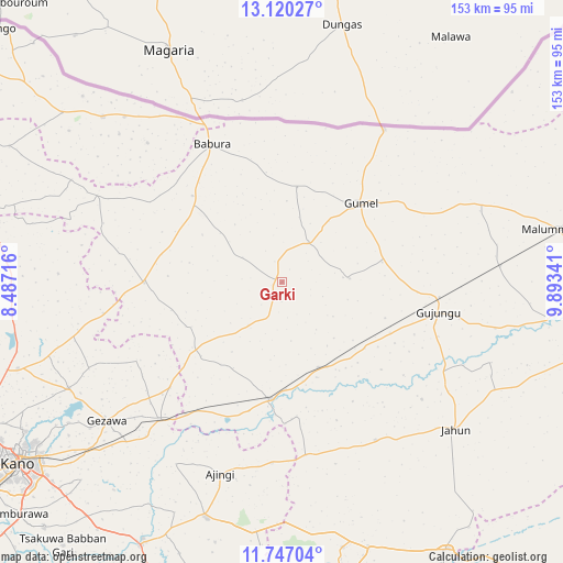
Garki GPS coordinates[2]
12° 26' 4.416" North, 9° 11' 25.008" East
| Map corner | latitude | longitude |
|---|---|---|
| Upper-left | 13.12027°, | 8.48716° |
| Center: | 12.43456°, | 9.19028° |
| Lower-right: | 11.74704°, | 9.89341° |
| Map W x H: | 152.7×152.7 km | = 94.9×94.9mi |
| max Lat: | 13.7543° ⇑10.4% North |
| Garki: | 12.43456° |
| min Lat: | ⇓89.6% South 4.31231° |
| min Long | Garki | max Long |
| 2.73333° | 9.19028° | 14.46552° |
| W 78.2%⇐ | ⇒21.8% E |
Elevation
Elevation of Garki is 380 m = 1247 ft, and this is 83.5 m = 274 ft above average elevation for this country.
| Max E: |
1599 m = 5246 ft | 32.9% |
| Garki | 380 m 1247 ft | |
| Avg. | 296.5 m = 973 ft | |
Min E: |
2 m = 7 ft | 67.1% |
See also: Nigeria elevation on elevation.city.
Geographical zone
Garki is located in North Torrid zone (between Equator and Tropic of Cancer). Distance of this Northern Tropic circle is 1223.3 km =760.1 mi to North.| Distance of | km | miles | from Garki |
|---|---|---|---|
| North Pole | 8624.5 | 5359 | to North |
| Arctic Circle | 6018.6 | 3739.8 | to North |
| Tropic Cancer | 1223.3 | 760.1 | to North |
| Equator | 1382.6 | 859.1 | to South |


Nearby cities:
15 places around Garki: (largest is in red/bold)
• Ajingi
54.5 km =33.9 mi,  197°
197°
• Babura
42.1 km =26.2 mi,  333°
333°
• Baure
65.9 km =40.9 mi,  312°
312°
• Gagarawa
36.9 km =22.9 mi,  94°
94°
• Gezawa
60.5 km =37.6 mi,  232°
232°
• Gumel
30.3 km =18.8 mi,  45°
45°
• Jahun
62 km =38.5 mi,  129°
129°
• Kaugama
59.5 km =37 mi, 85°
• Maigatari
49.9 km =31 mi,  33°
33°
• Miga
60.9 km =37.8 mi,  110°
110°
• Minjibir
64.5 km =40.1 mi,  243°
243°
• Ringim
31.6 km =19.6 mi,  185°
185°
• Sule Tankarkar
26.2 km =16.3 mi,  9°
9°
• Taura
25.2 km =15.7 mi,  156°
156°
• Zakirai
49.8 km =30.9 mi,  221°
221°
Sources, notices
• [Note1] Compared only with cities in Nigeria existing in our database
• [Src1] Map data: © OpenStreetMap contributors (CC-BY-SA)
• [Src2] Other city data from geonames.org with taken over terms of usage.
• [Src3] Geographical zone / Annual Mean Temperature by Robert A. Rohde @ Wikipedia
