Jahun geodata
Jahun (Jigawa) is a seat of a second-order administrative division; located in Nigeria in Africa/Lagos (GMT+1) time zone. In our database, there are 451 cities with bigger population. Compared to other cities in Nigeria, 84.6% of cities are located further ↓South; 81.5% of cities are located further ←West and 65.9% of cities have lower elevation than Jahun. Note1


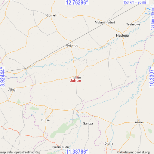
Jahun GPS coordinates[2]
12° 4' 34.644" North, 9° 37' 39.252" East
| Map corner | latitude | longitude |
|---|---|---|
| Upper-left | 12.76296°, | 8.92444° |
| Center: | 12.07629°, | 9.62757° |
| Lower-right: | 11.38786°, | 10.3307° |
| Map W x H: | 152.9×152.9 km | = 95×95mi |
| max Lat: | 13.7543° ⇑15.4% North |
| Jahun: | 12.07629° |
| min Lat: | ⇓84.6% South 4.31231° |
| min Long | Jahun | max Long |
| 2.73333° | 9.62757° | 14.46552° |
| W 81.5%⇐ | ⇒18.5% E |
Elevation
Elevation of Jahun is 374 m = 1227 ft, and this is 77.5 m = 254 ft above average elevation for this country.
| Max E: |
1599 m = 5246 ft | 34.1% |
| Jahun | 374 m 1227 ft | |
| Avg. | 296.5 m = 973 ft | |
Min E: |
2 m = 7 ft | 65.9% |
See also: Nigeria elevation on elevation.city.
Geographical zone
Jahun is located in North Torrid zone (between Equator and Tropic of Cancer). Distance of this Northern Tropic circle is 1263.2 km =784.9 mi to North.| Distance of | km | miles | from Jahun |
|---|---|---|---|
| North Pole | 8664.3 | 5383.7 | to North |
| Arctic Circle | 6058.4 | 3764.5 | to North |
| Tropic Cancer | 1263.2 | 784.9 | to North |
| Equator | 1342.8 | 834.4 | to South |


Nearby cities:
15 places around Jahun: (largest is in red/bold)
• Auyo
44.3 km =27.5 mi,  49°
49°
• Dutse
47.5 km =29.5 mi,  221°
221°
• Gagarawa
38.5 km =23.9 mi,  343°
343°
• Gantsa
47.2 km =29.3 mi,  166°
166°
• Garki
62 km =38.5 mi,  309°
309°
• Hadejia
61.5 km =38.2 mi, 46°
• Itas
43.9 km =27.3 mi,  123°
123°
• Jama’are
55.8 km =34.7 mi,  144°
144°
• Kafin Hausa
35.8 km =22.2 mi,  59°
59°
• Kaugama
45.8 km =28.5 mi,  14°
14°
• Kiyawa
32.5 km =20.2 mi,  183°
183°
• Malam Madori
60.9 km =37.8 mi,  26°
26°
• Miga
20.3 km =12.6 mi, 27°
• Ringim
51.3 km =31.9 mi,  279°
279°
• Taura
41 km =25.5 mi,  294°
294°
Sources, notices
• [Note1] Compared only with cities in Nigeria existing in our database
• [Src1] Map data: © OpenStreetMap contributors (CC-BY-SA)
• [Src2] Other city data from geonames.org with taken over terms of usage.
• [Src3] Geographical zone / Annual Mean Temperature by Robert A. Rohde @ Wikipedia
