Sule Tankarkar geodata
Sule Tankarkar (Jigawa) is a seat of a second-order administrative division; located in Nigeria in Africa/Lagos (GMT+1) time zone. In our database, there are 451 cities with bigger population. Compared to other cities in Nigeria, 92.9% of cities are located further ↓South; 78.7% of cities are located further ←West and 66.2% of cities have lower elevation than Sule Tankarkar. Note1


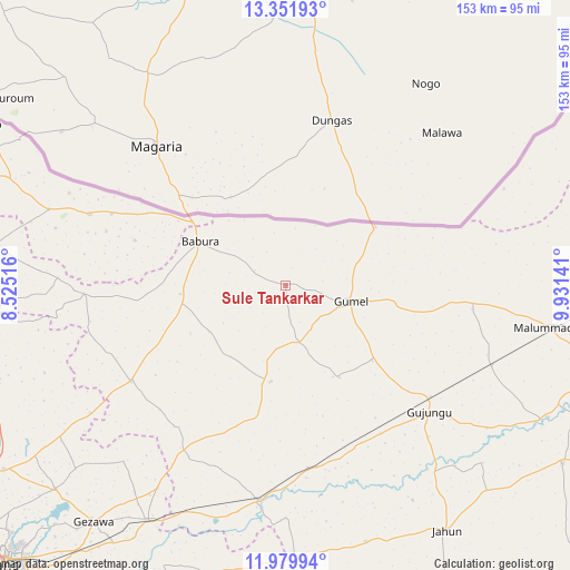
Sule Tankarkar GPS coordinates[2]
12° 40' 0.696" North, 9° 13' 41.808" East
| Map corner | latitude | longitude |
|---|---|---|
| Upper-left | 13.35193°, | 8.52516° |
| Center: | 12.66686°, | 9.22828° |
| Lower-right: | 11.97994°, | 9.93141° |
| Map W x H: | 152.6×152.6 km | = 94.8×94.8mi |
| max Lat: | 13.7543° ⇑7.1% North |
| Sule Tankarkar: | 12.66686° |
| min Lat: | ⇓92.9% South 4.31231° |
| min Long | Sule Tankarkar | max Long |
| 2.73333° | 9.22828° | 14.46552° |
| W 78.7%⇐ | ⇒21.3% E |
Elevation
Elevation of Sule Tankarkar is 377 m = 1237 ft, and this is 80.5 m = 264 ft above average elevation for this country.
| Max E: |
1599 m = 5246 ft | 33.8% |
| Sule Tankarkar | 377 m 1237 ft | |
| Avg. | 296.5 m = 973 ft | |
Min E: |
2 m = 7 ft | 66.2% |
See also: Nigeria elevation on elevation.city.
Geographical zone
Sule Tankarkar is located in North Torrid zone (between Equator and Tropic of Cancer). Distance of this Northern Tropic circle is 1197.5 km =744.1 mi to North.| Distance of | km | miles | from Sule Tankarkar |
|---|---|---|---|
| North Pole | 8598.6 | 5342.9 | to North |
| Arctic Circle | 5992.8 | 3723.8 | to North |
| Tropic Cancer | 1197.5 | 744.1 | to North |
| Equator | 1408.4 | 875.1 | to South |


Nearby cities:
15 places around Sule Tankarkar: (largest is in red/bold)
• Babura
25.9 km =16.1 mi,  296°
296°
• Baure
55.7 km =34.6 mi,  289°
289°
• Gagarawa
43.5 km =27 mi,  131°
131°
• Garki
26.2 km =16.3 mi,  189°
189°
• Gumel
17.9 km =11.1 mi,  104°
104°
• Jahun
78.7 km =48.9 mi,  146°
146°
• Karkarna
78.7 km =48.9 mi,  278°
278°
• Kaugama
59.2 km =36.8 mi,  111°
111°
• Maigatari
28.3 km =17.6 mi,  56°
56°
• Malam Madori
71.7 km =44.6 mi, 99°
• Mallammaduri
79.9 km =49.6 mi, 98°
• Miga
71 km =44.1 mi, 132°
• Ringim
57.8 km =35.9 mi, 187°
• Taura
49.3 km =30.6 mi,  173°
173°
• Zakirai
73.2 km =45.5 mi,  210°
210°
Sources, notices
• [Note1] Compared only with cities in Nigeria existing in our database
• [Src1] Map data: © OpenStreetMap contributors (CC-BY-SA)
• [Src2] Other city data from geonames.org with taken over terms of usage.
• [Src3] Geographical zone / Annual Mean Temperature by Robert A. Rohde @ Wikipedia
