Babura geodata
Babura (Jigawa) is a seat of a second-order administrative division; located in Nigeria in Africa/Lagos (GMT+1) time zone. With population of 7,267 people, there are 409 cities with bigger population in this country. Compared to other cities in Nigeria, 94.4% of cities are located further ↓South; 76.8% of cities are located further ←West and 67.8% of cities have lower elevation than Babura. Note1


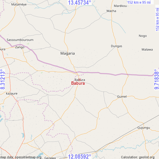
Babura GPS coordinates[2]
12° 46' 21.216" North, 9° 0' 54.9" East
| Map corner | latitude | longitude |
|---|---|---|
| Upper-left | 13.45734°, | 8.31213° |
| Center: | 12.77256°, | 9.01525° |
| Lower-right: | 12.08592°, | 9.71838° |
| Map W x H: | 152.5×152.5 km | = 94.8×94.8mi |
| max Lat: | 13.7543° ⇑5.6% North |
| Babura: | 12.77256° |
| min Lat: | ⇓94.4% South 4.31231° |
| min Long | Babura | max Long |
| 2.73333° | 9.01525° | 14.46552° |
| W 76.8%⇐ | ⇒23.2% E |
Elevation
Elevation of Babura is 384 m = 1260 ft, and this is 87.5 m = 287 ft above average elevation for this country.
| Max E: |
1599 m = 5246 ft | 32.2% |
| Babura | 384 m 1260 ft | |
| Avg. | 296.5 m = 973 ft | |
Min E: |
2 m = 7 ft | 67.8% |
See also: Nigeria elevation on elevation.city.
Geographical zone
Babura is located in North Torrid zone (between Equator and Tropic of Cancer). Distance of this Northern Tropic circle is 1185.7 km =736.8 mi to North.| Distance of | km | miles | from Babura |
|---|---|---|---|
| North Pole | 8586.9 | 5335.7 | to North |
| Arctic Circle | 5981 | 3716.4 | to North |
| Tropic Cancer | 1185.7 | 736.8 | to North |
| Equator | 1420.2 | 882.5 | to South |


Nearby cities:
15 places around Babura: (largest is in red/bold)
• Baure
30.2 km =18.8 mi,  283°
283°
• Dambatta
66 km =41 mi,  235°
235°
• Gagarawa
68.9 km =42.8 mi,  125°
125°
• Garki
42.1 km =26.2 mi,  153°
153°
• Gumel
43.6 km =27.1 mi,  111°
111°
• Gwiwa
73.5 km =45.7 mi,  270°
270°
• Karkarna
54.8 km =34.1 mi, 269°
• Kazaure
66.9 km =41.6 mi,  258°
258°
• Koguna
74.6 km =46.4 mi,  234°
234°
• Maigatari
46.8 km =29.1 mi,  85°
85°
• Ringim
70.9 km =44.1 mi,  166°
166°
• Sandamu
74.1 km =46 mi,  286°
286°
• Sule Tankarkar
25.9 km =16.1 mi,  116°
116°
• Taura
67.3 km =41.8 mi, 154°
• Zango
65.3 km =40.6 mi,  298°
298°
Sources, notices
• [Note1] Compared only with cities in Nigeria existing in our database
• [Src1] Map data: © OpenStreetMap contributors (CC-BY-SA)
• [Src2] Other city data from geonames.org with taken over terms of usage.
• [Src3] Geographical zone / Annual Mean Temperature by Robert A. Rohde @ Wikipedia
