Enugu-Ezike geodata
Enugu-Ezike (Enugu) is a seat of a second-order administrative division; located in Nigeria in Africa/Lagos (GMT+1) time zone. With population of 18,989 people, there are 206 cities with bigger population in this country. Compared to other cities in Nigeria, 68.5% of cities are located further ↑North; 52.8% of cities are located further ←West and 66.1% of cities have lower elevation than Enugu-Ezike. Note1


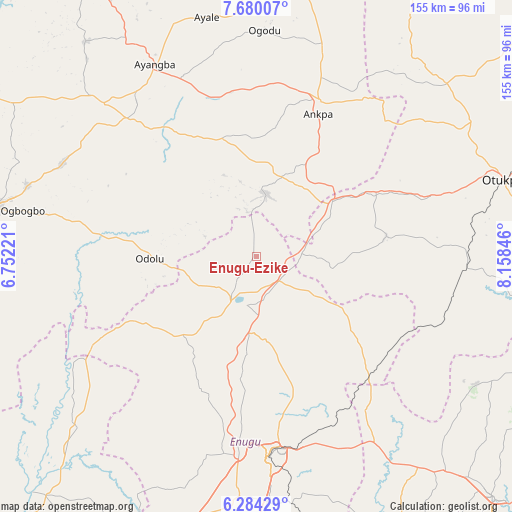
Enugu-Ezike GPS coordinates[2]
6° 58' 57.72" North, 7° 27' 19.224" East
| Map corner | latitude | longitude |
|---|---|---|
| Upper-left | 7.68007°, | 6.75221° |
| Center: | 6.9827°, | 7.45534° |
| Lower-right: | 6.28429°, | 8.15846° |
| Map W x H: | 155.2×155.2 km | = 96.4×96.4mi |
| max Lat: | 13.7543° ⇑68.5% North |
| Enugu-Ezike: | 6.9827° |
| min Lat: | ⇓31.5% South 4.31231° |
| min Long | Enugu-Ezike | max Long |
| 2.73333° | 7.45534° | 14.46552° |
| W 52.8%⇐ | ⇒47.2% E |
Elevation
Elevation of Enugu-Ezike is 376 m = 1234 ft, and this is 79.5 m = 261 ft above average elevation for this country.
| Max E: |
1599 m = 5246 ft | 33.9% |
| Enugu-Ezike | 376 m 1234 ft | |
| Avg. | 296.5 m = 973 ft | |
Min E: |
2 m = 7 ft | 66.1% |
See also: Nigeria elevation on elevation.city.
Geographical zone
Enugu-Ezike is located in North Torrid zone (between Equator and Tropic of Cancer). Distance of Equator is 776.4 km =482.4 mi to South.| Distance of | km | miles | from Enugu-Ezike |
|---|---|---|---|
| North Pole | 9230.7 | 5735.7 | to North |
| Arctic Circle | 6624.8 | 4116.5 | to North |
| Tropic Cancer | 1829.5 | 1136.8 | to North |
| Equator | 776.4 | 482.4 | to South |


Nearby cities:
15 places around Enugu-Ezike: (largest is in red/bold)
• Adoru
32.3 km =20.1 mi,  268°
268°
• Aku
34 km =21.1 mi,  206°
206°
• Ankpa
50.6 km =31.4 mi,  22°
22°
• Eha Amufu
49.2 km =30.6 mi,  136°
136°
• Ete
11.9 km =7.4 mi,  358°
358°
• Ibagwa-Aka
9.5 km =5.9 mi,  221°
221°
• Ikem
36.5 km =22.7 mi,  128°
128°
• Nsukka
15.4 km =9.6 mi, 205°
• Obollo-Afor
10.2 km =6.3 mi, 136°
• Obolo-Eke (1)
22.5 km =14 mi,  119°
119°
• Ogbede
35.6 km =22.1 mi,  194°
194°
• Okpo
28.4 km =17.6 mi, 24°
• Okpoga
39.9 km =24.8 mi,  80°
80°
• Opi
22.4 km =13.9 mi, 186°
• Otukpa
26.1 km =16.2 mi,  59°
59°
Sources, notices
• [Note1] Compared only with cities in Nigeria existing in our database
• [Src1] Map data: © OpenStreetMap contributors (CC-BY-SA)
• [Src2] Other city data from geonames.org with taken over terms of usage.
• [Src3] Geographical zone / Annual Mean Temperature by Robert A. Rohde @ Wikipedia
