Ankpa geodata
Ankpa (Kogi) is a seat of a second-order administrative division; located in Nigeria in Africa/Lagos (GMT+1) time zone. With population of 14,630 people, there are 246 cities with bigger population in this country. Compared to other cities in Nigeria, 63.4% of cities are located further ↑North; 56% of cities are located further ←West and 58.2% of cities have lower elevation than Ankpa. Note1


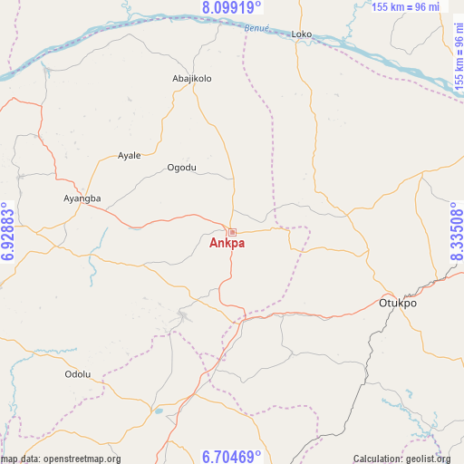
Ankpa GPS coordinates[2]
7° 24' 8.964" North, 7° 37' 55.056" East
| Map corner | latitude | longitude |
|---|---|---|
| Upper-left | 8.09919°, | 6.92883° |
| Center: | 7.40249°, | 7.63196° |
| Lower-right: | 6.70469°, | 8.33508° |
| Map W x H: | 155.1×155.1 km | = 96.4×96.4mi |
| max Lat: | 13.7543° ⇑63.4% North |
| Ankpa: | 7.40249° |
| min Lat: | ⇓36.6% South 4.31231° |
| min Long | Ankpa | max Long |
| 2.73333° | 7.63196° | 14.46552° |
| W 56%⇐ | ⇒44% E |
Elevation
Elevation of Ankpa is 334 m = 1096 ft, and this is 37.5 m = 123 ft above average elevation for this country.
| Max E: |
1599 m = 5246 ft | 41.8% |
| Ankpa | 334 m 1096 ft | |
| Avg. | 296.5 m = 973 ft | |
Min E: |
2 m = 7 ft | 58.2% |
See also: Nigeria elevation on elevation.city.
Geographical zone
Ankpa is located in North Torrid zone (between Equator and Tropic of Cancer). Distance of Equator is 823.1 km =511.5 mi to South.| Distance of | km | miles | from Ankpa |
|---|---|---|---|
| North Pole | 9184 | 5706.7 | to North |
| Arctic Circle | 6578.1 | 4087.4 | to North |
| Tropic Cancer | 1782.8 | 1107.8 | to North |
| Equator | 823.1 | 511.5 | to South |


Nearby cities:
15 places around Ankpa: (largest is in red/bold)
• Abejukolo
53.5 km =33.2 mi,  345°
345°
• Boju
29.3 km =18.2 mi,  100°
100°
• Enugu-Ezike
50.6 km =31.4 mi,  202°
202°
• Ete
40 km =24.9 mi,  209°
209°
• Ibagwa-Aka
59.6 km =37 mi, 205°
• Naka
66.2 km =41.1 mi,  72°
72°
• Nsukka
65.9 km =40.9 mi, 203°
• Obagaji
62.4 km =38.8 mi,  29°
29°
• Obollo-Afor
55.5 km =34.5 mi,  193°
193°
• Obolo-Eke (1)
57.7 km =35.9 mi,  179°
179°
• Ochobo
45.9 km =28.5 mi,  122°
122°
• Okpo
22.2 km =13.8 mi, 200°
• Okpoga
45 km =28 mi,  153°
153°
• Otukpa
33.6 km =20.9 mi,  174°
174°
• Ugbokpo
39.4 km =24.5 mi,  44°
44°
Sources, notices
• [Note1] Compared only with cities in Nigeria existing in our database
• [Src1] Map data: © OpenStreetMap contributors (CC-BY-SA)
• [Src2] Other city data from geonames.org with taken over terms of usage.
• [Src3] Geographical zone / Annual Mean Temperature by Robert A. Rohde @ Wikipedia
