Gassol geodata
Gassol (Taraba) is a populated place; located in Nigeria in Africa/Lagos (GMT+1) time zone. With population of 14,326 people, there are 253 cities with bigger population in this country. Compared to other cities in Nigeria, 51.2% of cities are located further ↓South; 86.9% of cities are located further ←West and 73% of cities have higher elevation than Gassol. Note1


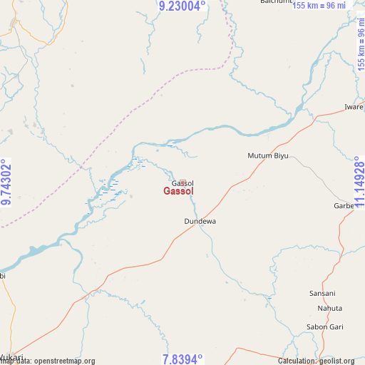
Gassol GPS coordinates[2]
8° 32' 7.26" North, 10° 26' 46.14" East
| Map corner | latitude | longitude |
|---|---|---|
| Upper-left | 9.23004°, | 9.74302° |
| Center: | 8.53535°, | 10.44615° |
| Lower-right: | 7.8394°, | 11.14928° |
| Map W x H: | 154.6×154.6 km | = 96.1×96.1mi |
| max Lat: | 13.7543° ⇑48.8% North |
| Gassol: | 8.53535° |
| min Lat: | ⇓51.2% South 4.31231° |
| min Long | Gassol | max Long |
| 2.73333° | 10.44615° | 14.46552° |
| W 86.9%⇐ | ⇒13.1% E |
Elevation
Elevation of Gassol is 132 m = 433 ft, and this is 164.5 m = 540 ft below average elevation for this country.
| Max E: |
1599 m = 5246 ft | 73% |
| Avg. | 296.5 m = 973 ft | |
| Gassol | 132 m = 433 ft | |
Min E: |
2 m = 7 ft | 27% |
See also: Nigeria elevation on elevation.city.
Geographical zone
Gassol is located in North Torrid zone (between Equator and Tropic of Cancer). Distance of Equator is 949 km =589.7 mi to South.| Distance of | km | miles | from Gassol |
|---|---|---|---|
| North Pole | 9058 | 5628.4 | to North |
| Arctic Circle | 6452.1 | 4009.1 | to North |
| Tropic Cancer | 1656.9 | 1029.5 | to North |
| Equator | 949 | 589.7 | to South |


Nearby cities:
15 places around Gassol: (largest is in red/bold)
• Beli
94.9 km =59 mi,  142°
142°
• Dengi
106.8 km =66.4 mi,  330°
330°
• Donga
100.7 km =62.6 mi,  206°
206°
• Ibi
86.7 km =53.9 mi,  242°
242°
• Jalingo
108 km =67.1 mi,  68°
68°
• Langtang
98.6 km =61.3 mi,  313°
313°
• Mabudi
75.8 km =47.1 mi,  286°
286°
• Mutum Biyu
37.9 km =23.5 mi, 71°
• Riti
114.8 km =71.3 mi,  232°
232°
• Shendam
107.2 km =66.6 mi, 290°
• Sunkani
91.1 km =56.6 mi,  78°
78°
• Tunkus
106.2 km =66 mi,  300°
300°
• Wase
82.2 km =51.1 mi,  319°
319°
• Wukari
104.2 km =64.7 mi,  224°
224°
• Yelwa
95.3 km =59.2 mi, 290°
Sources, notices
• [Note1] Compared only with cities in Nigeria existing in our database
• [Src1] Map data: © OpenStreetMap contributors (CC-BY-SA)
• [Src2] Other city data from geonames.org with taken over terms of usage.
• [Src3] Geographical zone / Annual Mean Temperature by Robert A. Rohde @ Wikipedia
