Baissa geodata
Baissa (Taraba) is a seat of a second-order administrative division; located in Nigeria in Africa/Lagos (GMT+1) time zone. With population of 8,911 people, there are 358 cities with bigger population in this country. Compared to other cities in Nigeria, 65.7% of cities are located further ↑North; 87.5% of cities are located further ←West and 54.9% of cities have higher elevation than Baissa. Note1


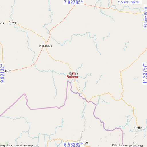
Baissa GPS coordinates[2]
7° 13' 51.132" North, 10° 37' 27.984" East
| Map corner | latitude | longitude |
|---|---|---|
| Upper-left | 7.92785°, | 9.92132° |
| Center: | 7.23087°, | 10.62444° |
| Lower-right: | 6.53282°, | 11.32757° |
| Map W x H: | 155.1×155.1 km | = 96.4×96.4mi |
| max Lat: | 13.7543° ⇑65.7% North |
| Baissa: | 7.23087° |
| min Lat: | ⇓34.3% South 4.31231° |
| min Long | Baissa | max Long |
| 2.73333° | 10.62444° | 14.46552° |
| W 87.5%⇐ | ⇒12.5% E |
Elevation
Elevation of Baissa is 248 m = 814 ft, and this is 48.5 m = 159 ft below average elevation for this country.
| Max E: |
1599 m = 5246 ft | 54.9% |
| Avg. | 296.5 m = 973 ft | |
| Baissa | 248 m = 814 ft | |
Min E: |
2 m = 7 ft | 45.1% |
See also: Nigeria elevation on elevation.city.
Geographical zone
Baissa is located in North Torrid zone (between Equator and Tropic of Cancer). Distance of Equator is 804 km =499.6 mi to South.| Distance of | km | miles | from Baissa |
|---|---|---|---|
| North Pole | 9203.1 | 5718.5 | to North |
| Arctic Circle | 6597.2 | 4099.3 | to North |
| Tropic Cancer | 1801.9 | 1119.6 | to North |
| Equator | 804 | 499.6 | to South |


Nearby cities:
15 places around Baissa: (largest is in red/bold)
• Beli
79.6 km =49.5 mi,  28°
28°
• Donga
84 km =52.2 mi,  310°
310°
• Gassol
146.4 km =91 mi,  352°
352°
• Gembu
89.6 km =55.7 mi,  128°
128°
• Ibi
143.4 km =89.1 mi,  317°
317°
• Katsina-Ala
148 km =92 mi,  267°
267°
• Lissam
63.9 km =39.7 mi, 266°
• Mutum Biyu
157.7 km =98 mi,  5°
5°
• Riti
134.2 km =83.4 mi,  304°
304°
• Sankera
112.4 km =69.8 mi,  287°
287°
• Serti
87 km =54.1 mi,  69°
69°
• Takum
70.8 km =44 mi, 273°
• Ugba
144.1 km =89.5 mi,  282°
282°
• Wukari
117.4 km =72.9 mi, 307°
• Zaki Biam
115.9 km =72 mi, 285°
Sources, notices
• [Note1] Compared only with cities in Nigeria existing in our database
• [Src1] Map data: © OpenStreetMap contributors (CC-BY-SA)
• [Src2] Other city data from geonames.org with taken over terms of usage.
• [Src3] Geographical zone / Annual Mean Temperature by Robert A. Rohde @ Wikipedia
