Dindima geodata
Dindima (Bauchi) is a populated place; located in Nigeria in Africa/Lagos (GMT+1) time zone. With population of 13,356 people, there are 267 cities with bigger population in this country. Compared to other cities in Nigeria, 66% of cities are located further ↓South; 85.2% of cities are located further ←West and 79.8% of cities have lower elevation than Dindima. Note1


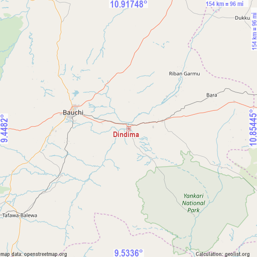
Dindima GPS coordinates[2]
10° 13' 34.644" North, 10° 9' 4.752" East
| Map corner | latitude | longitude |
|---|---|---|
| Upper-left | 10.91748°, | 9.4482° |
| Center: | 10.22629°, | 10.15132° |
| Lower-right: | 9.5336°, | 10.85445° |
| Map W x H: | 153.9×153.9 km | = 95.6×95.6mi |
| max Lat: | 13.7543° ⇑34% North |
| Dindima: | 10.22629° |
| min Lat: | ⇓66% South 4.31231° |
| min Long | Dindima | max Long |
| 2.73333° | 10.15132° | 14.46552° |
| W 85.2%⇐ | ⇒14.8% E |
Elevation
Elevation of Dindima is 470 m = 1542 ft, and this is 173.5 m = 569 ft above average elevation for this country.
| Max E: |
1599 m = 5246 ft | 20.2% |
| Dindima | 470 m 1542 ft | |
| Avg. | 296.5 m = 973 ft | |
Min E: |
2 m = 7 ft | 79.8% |
See also: Nigeria elevation on elevation.city.
Geographical zone
Dindima is located in North Torrid zone (between Equator and Tropic of Cancer). Distance of Equator is 1137.1 km =706.6 mi to South.| Distance of | km | miles | from Dindima |
|---|---|---|---|
| North Pole | 8870 | 5511.6 | to North |
| Arctic Circle | 6264.1 | 3892.3 | to North |
| Tropic Cancer | 1468.9 | 912.7 | to North |
| Equator | 1137.1 | 706.6 | to South |


Nearby cities:
15 places around Dindima: (largest is in red/bold)
• Akko
90.2 km =56 mi,  85°
85°
• Alkaleri
20.3 km =12.6 mi,  77°
77°
• Bara
65.3 km =40.6 mi, 75°
• Bauchi
34.9 km =21.7 mi,  285°
285°
• Bogoro
86.1 km =53.5 mi,  223°
223°
• Bununu
64.2 km =39.9 mi,  233°
233°
• Darazo
90.5 km =56.2 mi,  18°
18°
• Dass
73.9 km =45.9 mi,  250°
250°
• Gwaram
14.7 km =9.1 mi, 87°
• Kafin Madaki
66.8 km =41.5 mi,  320°
320°
• Kirfi
34.1 km =21.2 mi,  54°
54°
• Tafawa Balewa
83.6 km =51.9 mi, 231°
• Yamrat
37.8 km =23.5 mi, 250°
• Yuli
60.3 km =37.5 mi,  167°
167°
• Zalanga
43.2 km =26.8 mi,  3°
3°
Sources, notices
• [Note1] Compared only with cities in Nigeria existing in our database
• [Src1] Map data: © OpenStreetMap contributors (CC-BY-SA)
• [Src2] Other city data from geonames.org with taken over terms of usage.
• [Src3] Geographical zone / Annual Mean Temperature by Robert A. Rohde @ Wikipedia
