Zalanga geodata
Zalanga (Bauchi) is a populated place; located in Nigeria in Africa/Lagos (GMT+1) time zone. With population of 12,070 people, there are 295 cities with bigger population in this country. Compared to other cities in Nigeria, 69.8% of cities are located further ↓South; 85.3% of cities are located further ←West and 89.8% of cities have lower elevation than Zalanga. Note1


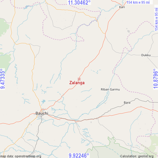
Zalanga GPS coordinates[2]
10° 36' 51.552" North, 10° 10' 35.292" East
| Map corner | latitude | longitude |
|---|---|---|
| Upper-left | 11.30462°, | 9.47335° |
| Center: | 10.61432°, | 10.17647° |
| Lower-right: | 9.92246°, | 10.8796° |
| Map W x H: | 153.7×153.7 km | = 95.5×95.5mi |
| max Lat: | 13.7543° ⇑30.2% North |
| Zalanga: | 10.61432° |
| min Lat: | ⇓69.8% South 4.31231° |
| min Long | Zalanga | max Long |
| 2.73333° | 10.17647° | 14.46552° |
| W 85.3%⇐ | ⇒14.7% E |
Elevation
Elevation of Zalanga is 554 m = 1818 ft, and this is 257.5 m = 845 ft above average elevation for this country.
| Max E: |
1599 m = 5246 ft | 10.2% |
| Zalanga | 554 m 1818 ft | |
| Avg. | 296.5 m = 973 ft | |
Min E: |
2 m = 7 ft | 89.8% |
See also: Nigeria elevation on elevation.city.
Geographical zone
Zalanga is located in North Torrid zone (between Equator and Tropic of Cancer). Distance of Equator is 1180.2 km =733.3 mi to South.| Distance of | km | miles | from Zalanga |
|---|---|---|---|
| North Pole | 8826.9 | 5484.8 | to North |
| Arctic Circle | 6221 | 3865.5 | to North |
| Tropic Cancer | 1425.7 | 885.9 | to North |
| Equator | 1180.2 | 733.3 | to South |


Nearby cities:
15 places around Zalanga: (largest is in red/bold)
• Alkaleri
42.2 km =26.2 mi,  156°
156°
• Bara
66 km =41 mi,  113°
113°
• Bauchi
49.6 km =30.8 mi,  227°
227°
• Darazo
49.9 km =31 mi,  30°
30°
• Dindima
43.2 km =26.8 mi,  183°
183°
• Dukku
69.1 km =42.9 mi,  70°
70°
• Gabarin
62.3 km =38.7 mi, 27°
• Gwaram
44.1 km =27.4 mi, 164°
• Gwaram
80.3 km =49.9 mi,  336°
336°
• Kafin Madaki
46.2 km =28.7 mi,  280°
280°
• Kari
81.9 km =50.9 mi, 30°
• Kirfi
34.1 km =21.2 mi,  132°
132°
• Misau
84 km =52.2 mi,  22°
22°
• Warji
77.9 km =48.4 mi,  323°
323°
• Yamrat
67.8 km =42.1 mi,  214°
214°
Sources, notices
• [Note1] Compared only with cities in Nigeria existing in our database
• [Src1] Map data: © OpenStreetMap contributors (CC-BY-SA)
• [Src2] Other city data from geonames.org with taken over terms of usage.
• [Src3] Geographical zone / Annual Mean Temperature by Robert A. Rohde @ Wikipedia
