Bauchi geodata
Bauchi is a seat of a first-order administrative division; located in Nigeria in Africa/Lagos (GMT+1) time zone. With population of 316,149 people, there are 25 cities with bigger population in this country. Compared to other cities in Nigeria, 67% of cities are located further ↓South; 83.3% of cities are located further ←West and 93.9% of cities have lower elevation than Bauchi. Note1


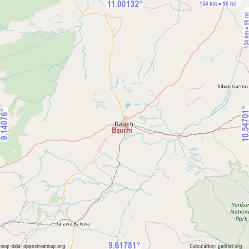
Bauchi GPS coordinates[2]
10° 18' 37.152" North, 9° 50' 37.968" East
| Map corner | latitude | longitude |
|---|---|---|
| Upper-left | 11.00132°, | 9.14076° |
| Center: | 10.31032°, | 9.84388° |
| Lower-right: | 9.61781°, | 10.54701° |
| Map W x H: | 153.8×153.8 km | = 95.6×95.6mi |
| max Lat: | 13.7543° ⇑33% North |
| Bauchi: | 10.31032° |
| min Lat: | ⇓67% South 4.31231° |
| min Long | Bauchi | max Long |
| 2.73333° | 9.84388° | 14.46552° |
| W 83.3%⇐ | ⇒16.7% E |
Elevation
Elevation of Bauchi is 623 m = 2044 ft, and this is 326.5 m = 1071 ft above average elevation for this country.
| Max E: |
1599 m = 5246 ft | 6.1% |
| Bauchi | 623 m 2044 ft | |
| Avg. | 296.5 m = 973 ft | |
Min E: |
2 m = 7 ft | 93.9% |
See also: Bauchi elevation on elevation.city.
Geographical zone
Bauchi is located in North Torrid zone (between Equator and Tropic of Cancer). Distance of Equator is 1146.4 km =712.3 mi to South.| Distance of | km | miles | from Bauchi |
|---|---|---|---|
| North Pole | 8860.7 | 5505.8 | to North |
| Arctic Circle | 6254.8 | 3886.6 | to North |
| Tropic Cancer | 1459.5 | 906.9 | to North |
| Equator | 1146.4 | 712.3 | to South |


Nearby cities:
15 places around Bauchi: (largest is in red/bold)
• Alkaleri
53.7 km =33.4 mi,  95°
95°
• Angware
88 km =54.7 mi,  246°
246°
• Bogoro
75.9 km =47.2 mi,  200°
200°
• Bununu
50.8 km =31.6 mi, 200°
• Dass
49.7 km =30.9 mi,  226°
226°
• Dindima
34.9 km =21.7 mi,  105°
105°
• Gwaram
49.1 km =30.5 mi, 100°
• Kafin Madaki
43 km =26.7 mi,  347°
347°
• Kirfi
62.2 km =38.6 mi,  80°
80°
• Lame
67.7 km =42.1 mi,  282°
282°
• Lere
86.5 km =53.7 mi,  219°
219°
• Tafawa Balewa
69 km =42.9 mi,  207°
207°
• Yamrat
22.2 km =13.8 mi,  185°
185°
• Yuli
82.8 km =51.4 mi,  145°
145°
• Zalanga
49.6 km =30.8 mi,  47°
47°
Sources, notices
• [Note1] Compared only with cities in Nigeria existing in our database
• [Src1] Map data: © OpenStreetMap contributors (CC-BY-SA)
• [Src2] Other city data from geonames.org with taken over terms of usage.
• [Src3] Geographical zone / Annual Mean Temperature by Robert A. Rohde @ Wikipedia
