Bununu geodata
Bununu (Bauchi) is a populated place; located in Nigeria in Africa/Lagos (GMT+1) time zone. With population of 6,123 people, there are 439 cities with bigger population in this country. Compared to other cities in Nigeria, 63% of cities are located further ↓South; 82% of cities are located further ←West and 91.8% of cities have lower elevation than Bununu. Note1


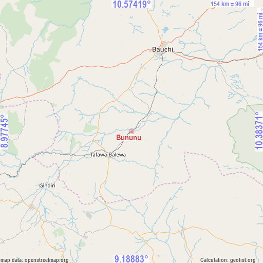
Bununu GPS coordinates[2]
9° 52' 56.064" North, 9° 40' 50.088" East
| Map corner | latitude | longitude |
|---|---|---|
| Upper-left | 10.57419°, | 8.97745° |
| Center: | 9.88224°, | 9.68058° |
| Lower-right: | 9.18883°, | 10.38371° |
| Map W x H: | 154×154 km | = 95.7×95.7mi |
| max Lat: | 13.7543° ⇑37% North |
| Bununu: | 9.88224° |
| min Lat: | ⇓63% South 4.31231° |
| min Long | Bununu | max Long |
| 2.73333° | 9.68058° | 14.46552° |
| W 82%⇐ | ⇒18% E |
Elevation
Elevation of Bununu is 579 m = 1900 ft, and this is 282.5 m = 927 ft above average elevation for this country.
| Max E: |
1599 m = 5246 ft | 8.2% |
| Bununu | 579 m 1900 ft | |
| Avg. | 296.5 m = 973 ft | |
Min E: |
2 m = 7 ft | 91.8% |
See also: Nigeria elevation on elevation.city.
Geographical zone
Bununu is located in North Torrid zone (between Equator and Tropic of Cancer). Distance of Equator is 1098.8 km =682.8 mi to South.| Distance of | km | miles | from Bununu |
|---|---|---|---|
| North Pole | 8908.3 | 5535.4 | to North |
| Arctic Circle | 6302.4 | 3916.1 | to North |
| Tropic Cancer | 1507.1 | 936.5 | to North |
| Equator | 1098.8 | 682.8 | to South |


Nearby cities:
15 places around Bununu: (largest is in red/bold)
• Amper
58.7 km =36.5 mi,  177°
177°
• Angware
63.9 km =39.7 mi,  280°
280°
• Bauchi
50.8 km =31.6 mi,  20°
20°
• Bogoro
25.1 km =15.6 mi,  199°
199°
• Boi
40.7 km =25.3 mi,  208°
208°
• Dass
22.3 km =13.9 mi,  306°
306°
• Dengi
64.9 km =40.3 mi,  151°
151°
• Dindima
64.2 km =39.9 mi,  53°
53°
• Kwal
57.2 km =35.5 mi,  186°
186°
• Lere
41.9 km =26 mi,  242°
242°
• Pankshin
67.5 km =41.9 mi, 203°
• Tafawa Balewa
19.6 km =12.2 mi,  226°
226°
• Toro
69.8 km =43.4 mi,  286°
286°
• Yamrat
30.1 km =18.7 mi,  31°
31°
• Yuli
68.2 km =42.4 mi,  107°
107°
Sources, notices
• [Note1] Compared only with cities in Nigeria existing in our database
• [Src1] Map data: © OpenStreetMap contributors (CC-BY-SA)
• [Src2] Other city data from geonames.org with taken over terms of usage.
• [Src3] Geographical zone / Annual Mean Temperature by Robert A. Rohde @ Wikipedia
