Ugbokpo geodata
Ugbokpo (Benue) is a seat of a second-order administrative division; located in Nigeria in Africa/Lagos (GMT+1) time zone. With population of 14,218 people, there are 255 cities with bigger population in this country. Compared to other cities in Nigeria, 58.3% of cities are located further ↑North; 61.3% of cities are located further ←West and 72% of cities have higher elevation than Ugbokpo. Note1


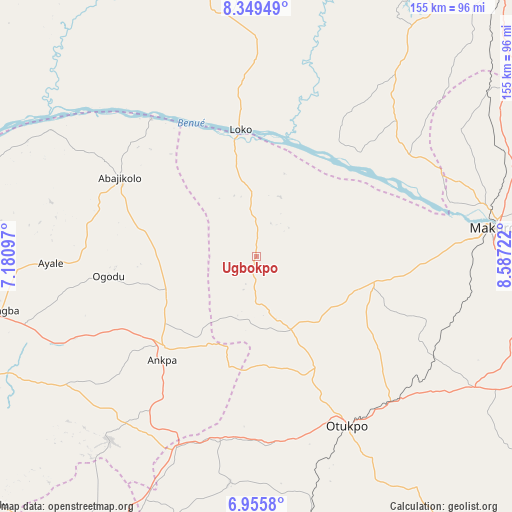
Ugbokpo GPS coordinates[2]
7° 39' 11.556" North, 7° 53' 2.76" East
| Map corner | latitude | longitude |
|---|---|---|
| Upper-left | 8.34949°, | 7.18097° |
| Center: | 7.65321°, | 7.8841° |
| Lower-right: | 6.9558°, | 8.58722° |
| Map W x H: | 155×155 km | = 96.3×96.3mi |
| max Lat: | 13.7543° ⇑58.3% North |
| Ugbokpo: | 7.65321° |
| min Lat: | ⇓41.7% South 4.31231° |
| min Long | Ugbokpo | max Long |
| 2.73333° | 7.8841° | 14.46552° |
| W 61.3%⇐ | ⇒38.7% E |
Elevation
Elevation of Ugbokpo is 138 m = 453 ft, and this is 158.5 m = 520 ft below average elevation for this country.
| Max E: |
1599 m = 5246 ft | 72% |
| Avg. | 296.5 m = 973 ft | |
| Ugbokpo | 138 m = 453 ft | |
Min E: |
2 m = 7 ft | 28% |
See also: Nigeria elevation on elevation.city.
Geographical zone
Ugbokpo is located in North Torrid zone (between Equator and Tropic of Cancer). Distance of Equator is 851 km =528.8 mi to South.| Distance of | km | miles | from Ugbokpo |
|---|---|---|---|
| North Pole | 9156.1 | 5689.3 | to North |
| Arctic Circle | 6550.2 | 4070.1 | to North |
| Tropic Cancer | 1755 | 1090.5 | to North |
| Equator | 851 | 528.8 | to South |


Nearby cities:
15 places around Ugbokpo: (largest is in red/bold)
• Abejukolo
47.7 km =29.6 mi,  300°
300°
• Aliade
77 km =47.8 mi,  121°
121°
• Ankpa
39.4 km =24.5 mi,  224°
224°
• Boju
33.1 km =20.6 mi,  178°
178°
• Bugana
50.7 km =31.5 mi,  319°
319°
• Ete
78.6 km =48.8 mi, 217°
• Igbor
82.9 km =51.5 mi,  105°
105°
• Makurdi
70.8 km =44 mi,  82°
82°
• Naka
36.1 km =22.4 mi,  102°
102°
• Obagaji
26.7 km =16.6 mi,  5°
5°
• Obarike-Ito
85.1 km =52.9 mi,  145°
145°
• Ochobo
53.7 km =33.4 mi,  168°
168°
• Okpo
60.3 km =37.5 mi, 216°
• Okpoga
68.7 km =42.7 mi,  186°
186°
• Otukpa
66.1 km =41.1 mi,  201°
201°
Sources, notices
• [Note1] Compared only with cities in Nigeria existing in our database
• [Src1] Map data: © OpenStreetMap contributors (CC-BY-SA)
• [Src2] Other city data from geonames.org with taken over terms of usage.
• [Src3] Geographical zone / Annual Mean Temperature by Robert A. Rohde @ Wikipedia
