Ochobo geodata
Ochobo (Benue) is a populated place; located in Nigeria in Africa/Lagos (GMT+1) time zone. With population of 8,567 people, there are 368 cities with bigger population in this country. Compared to other cities in Nigeria, 66.5% of cities are located further ↑North; 63.4% of cities are located further ←West and 73.9% of cities have higher elevation than Ochobo. Note1


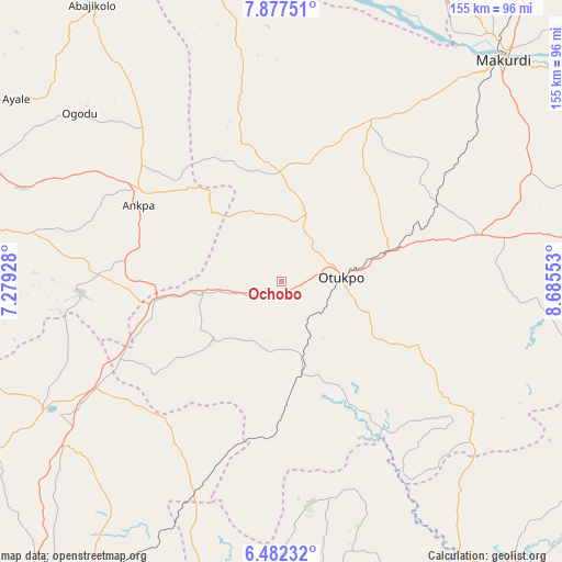
Ochobo GPS coordinates[2]
7° 10' 49.62" North, 7° 58' 56.64" East
| Map corner | latitude | longitude |
|---|---|---|
| Upper-left | 7.87751°, | 7.27928° |
| Center: | 7.18045°, | 7.9824° |
| Lower-right: | 6.48232°, | 8.68553° |
| Map W x H: | 155.1×155.1 km | = 96.4×96.4mi |
| max Lat: | 13.7543° ⇑66.5% North |
| Ochobo: | 7.18045° |
| min Lat: | ⇓33.5% South 4.31231° |
| min Long | Ochobo | max Long |
| 2.73333° | 7.9824° | 14.46552° |
| W 63.4%⇐ | ⇒36.6% E |
Elevation
Elevation of Ochobo is 127 m = 417 ft, and this is 169.5 m = 556 ft below average elevation for this country.
| Max E: |
1599 m = 5246 ft | 73.9% |
| Avg. | 296.5 m = 973 ft | |
| Ochobo | 127 m = 417 ft | |
Min E: |
2 m = 7 ft | 26.1% |
See also: Nigeria elevation on elevation.city.
Geographical zone
Ochobo is located in North Torrid zone (between Equator and Tropic of Cancer). Distance of Equator is 798.4 km =496.1 mi to South.| Distance of | km | miles | from Ochobo |
|---|---|---|---|
| North Pole | 9208.7 | 5722 | to North |
| Arctic Circle | 6602.8 | 4102.8 | to North |
| Tropic Cancer | 1807.5 | 1123.1 | to North |
| Equator | 798.4 | 496.1 | to South |


Nearby cities:
15 places around Ochobo: (largest is in red/bold)
• Aliade
56.7 km =35.2 mi,  76°
76°
• Ankpa
45.9 km =28.5 mi,  302°
302°
• Boju
21.8 km =13.5 mi,  333°
333°
• Ete
59.2 km =36.8 mi,  260°
260°
• Igumale
42.6 km =26.5 mi,  182°
182°
• Ikem
53.4 km =33.2 mi,  213°
213°
• Naka
51 km =31.7 mi,  28°
28°
• Obarike-Ito
41.4 km =25.7 mi,  114°
114°
• Obollo-Afor
59 km =36.7 mi,  240°
240°
• Obolo-Eke (1)
50.7 km =31.5 mi,  229°
229°
• Oju
60.9 km =37.8 mi,  127°
127°
• Okpo
46.7 km =29 mi,  274°
274°
• Okpoga
24.5 km =15.2 mi, 230°
• Otukpa
36.7 km =22.8 mi, 256°
• Ugbokpo
53.7 km =33.4 mi,  348°
348°
Sources, notices
• [Note1] Compared only with cities in Nigeria existing in our database
• [Src1] Map data: © OpenStreetMap contributors (CC-BY-SA)
• [Src2] Other city data from geonames.org with taken over terms of usage.
• [Src3] Geographical zone / Annual Mean Temperature by Robert A. Rohde @ Wikipedia
