Boju geodata
Boju (Benue) is a populated place; located in Nigeria in Africa/Lagos (GMT+1) time zone. With population of 12,814 people, there are 278 cities with bigger population in this country. Compared to other cities in Nigeria, 64.3% of cities are located further ↑North; 61.4% of cities are located further ←West and 59.1% of cities have higher elevation than Boju. Note1


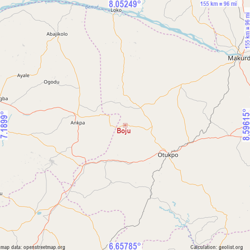
Boju GPS coordinates[2]
7° 21' 20.592" North, 7° 53' 34.908" East
| Map corner | latitude | longitude |
|---|---|---|
| Upper-left | 8.05249°, | 7.1899° |
| Center: | 7.35572°, | 7.89303° |
| Lower-right: | 6.65785°, | 8.59615° |
| Map W x H: | 155.1×155.1 km | = 96.4×96.4mi |
| max Lat: | 13.7543° ⇑64.3% North |
| Boju: | 7.35572° |
| min Lat: | ⇓35.7% South 4.31231° |
| min Long | Boju | max Long |
| 2.73333° | 7.89303° | 14.46552° |
| W 61.4%⇐ | ⇒38.6% E |
Elevation
Elevation of Boju is 215 m = 705 ft, and this is 81.5 m = 267 ft below average elevation for this country.
| Max E: |
1599 m = 5246 ft | 59.1% |
| Avg. | 296.5 m = 973 ft | |
| Boju | 215 m = 705 ft | |
Min E: |
2 m = 7 ft | 40.9% |
See also: Nigeria elevation on elevation.city.
Geographical zone
Boju is located in North Torrid zone (between Equator and Tropic of Cancer). Distance of Equator is 817.9 km =508.2 mi to South.| Distance of | km | miles | from Boju |
|---|---|---|---|
| North Pole | 9189.2 | 5709.9 | to North |
| Arctic Circle | 6583.3 | 4090.7 | to North |
| Tropic Cancer | 1788 | 1111 | to North |
| Equator | 817.9 | 508.2 | to South |


Nearby cities:
15 places around Boju: (largest is in red/bold)
• Aliade
65.4 km =40.6 mi,  95°
95°
• Ankpa
29.3 km =18.2 mi,  280°
280°
• Enugu-Ezike
63.7 km =39.6 mi,  229°
229°
• Ete
56.8 km =35.3 mi,  238°
238°
• Igumale
62.6 km =38.9 mi,  172°
172°
• Naka
42.6 km =26.5 mi,  53°
53°
• Obagaji
59.6 km =37 mi,  1°
1°
• Obarike-Ito
60.1 km =37.3 mi,  127°
127°
• Obollo-Afor
64 km =39.8 mi,  220°
220°
• Obolo-Eke (1)
59.8 km =37.2 mi,  208°
208°
• Ochobo
21.8 km =13.5 mi,  153°
153°
• Okpo
39.8 km =24.7 mi,  247°
247°
• Okpoga
36.3 km =22.6 mi,  194°
194°
• Otukpa
38.2 km =23.7 mi, 222°
• Ugbokpo
33.1 km =20.6 mi,  358°
358°
Sources, notices
• [Note1] Compared only with cities in Nigeria existing in our database
• [Src1] Map data: © OpenStreetMap contributors (CC-BY-SA)
• [Src2] Other city data from geonames.org with taken over terms of usage.
• [Src3] Geographical zone / Annual Mean Temperature by Robert A. Rohde @ Wikipedia
