Katsina geodata
Katsina is a seat of a first-order administrative division; located in Nigeria in Africa/Lagos (GMT+1) time zone. With population of 432,149 people, there are 22 cities with bigger population in this country. Compared to other cities in Nigeria, 97% of cities are located further ↓South; 55.4% of cities are located further ←West and 86.5% of cities have lower elevation than Katsina. Note1


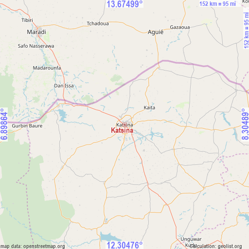
Katsina GPS coordinates[2]
12° 59' 26.952" North, 7° 36' 6.372" East
| Map corner | latitude | longitude |
|---|---|---|
| Upper-left | 13.67499°, | 6.89864° |
| Center: | 12.99082°, | 7.60177° |
| Lower-right: | 12.30476°, | 8.30489° |
| Map W x H: | 152.4×152.4 km | = 94.7×94.7mi |
| max Lat: | 13.7543° ⇑3% North |
| Katsina: | 12.99082° |
| min Lat: | ⇓97% South 4.31231° |
| min Long | Katsina | max Long |
| 2.73333° | 7.60177° | 14.46552° |
| W 55.4%⇐ | ⇒44.6% E |
Elevation
Elevation of Katsina is 519 m = 1703 ft, and this is 222.5 m = 730 ft above average elevation for this country.
| Max E: |
1599 m = 5246 ft | 13.5% |
| Katsina | 519 m 1703 ft | |
| Avg. | 296.5 m = 973 ft | |
Min E: |
2 m = 7 ft | 86.5% |
See also: Katsina elevation on elevation.city.
Geographical zone
Katsina is located in North Torrid zone (between Equator and Tropic of Cancer). Distance of this Northern Tropic circle is 1161.5 km =721.7 mi to North.| Distance of | km | miles | from Katsina |
|---|---|---|---|
| North Pole | 8562.6 | 5320.6 | to North |
| Arctic Circle | 5956.7 | 3701.3 | to North |
| Tropic Cancer | 1161.5 | 721.7 | to North |
| Equator | 1444.4 | 897.5 | to South |


Nearby cities:
15 places around Katsina: (largest is in red/bold)
• Batagarawa
9.4 km =5.8 mi,  177°
177°
• Batsari
46.4 km =28.8 mi,  235°
235°
• Bindawa
42.1 km =26.2 mi,  147°
147°
• Charanchi
38.1 km =23.7 mi,  158°
158°
• Dankama
40 km =24.9 mi,  31°
31°
• Dutsin-Ma
60.8 km =37.8 mi,  190°
190°
• Jibia
42.3 km =26.3 mi,  285°
285°
• Kaita
18.3 km =11.4 mi,  55°
55°
• Kankia
54.9 km =34.1 mi, 154°
• Kurfi
38.2 km =23.7 mi,  199°
199°
• Mani
33.3 km =20.7 mi,  117°
117°
• Mashi
37.4 km =23.2 mi,  91°
91°
• Rimi
19.5 km =12.1 mi,  143°
143°
• Ruma
42.3 km =26.3 mi,  250°
250°
• Wagini
55.4 km =34.4 mi,  232°
232°
Sources, notices
• [Note1] Compared only with cities in Nigeria existing in our database
• [Src1] Map data: © OpenStreetMap contributors (CC-BY-SA)
• [Src2] Other city data from geonames.org with taken over terms of usage.
• [Src3] Geographical zone / Annual Mean Temperature by Robert A. Rohde @ Wikipedia
