Owu-Isin geodata
Owu-Isin (Kwara) is a seat of a second-order administrative division; located in Nigeria in Africa/Lagos (GMT+1) time zone. In our database, there are 451 cities with bigger population. Compared to other cities in Nigeria, 50.3% of cities are located further ↑North; 81.2% of cities are located further →East and 75.2% of cities have lower elevation than Owu-Isin. Note1


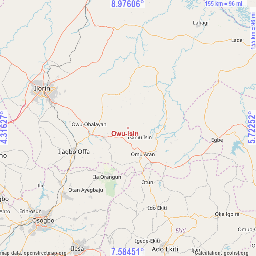
Owu-Isin GPS coordinates[2]
8° 16' 51.24" North, 5° 1' 9.84" East
| Map corner | latitude | longitude |
|---|---|---|
| Upper-left | 8.97606°, | 4.31627° |
| Center: | 8.2809°, | 5.0194° |
| Lower-right: | 7.58451°, | 5.72252° |
| Map W x H: | 154.7×154.7 km | = 96.1×96.1mi |
| max Lat: | 13.7543° ⇑50.3% North |
| Owu-Isin: | 8.2809° |
| min Lat: | ⇓49.7% South 4.31231° |
| min Long | Owu-Isin | max Long |
| 2.73333° | 5.0194° | 14.46552° |
| W 18.8%⇐ | ⇒81.2% E |
Elevation
Elevation of Owu-Isin is 434 m = 1424 ft, and this is 137.5 m = 451 ft above average elevation for this country.
| Max E: |
1599 m = 5246 ft | 24.8% |
| Owu-Isin | 434 m 1424 ft | |
| Avg. | 296.5 m = 973 ft | |
Min E: |
2 m = 7 ft | 75.2% |
See also: Nigeria elevation on elevation.city.
Geographical zone
Owu-Isin is located in North Torrid zone (between Equator and Tropic of Cancer). Distance of Equator is 920.7 km =572.1 mi to South.| Distance of | km | miles | from Owu-Isin |
|---|---|---|---|
| North Pole | 9086.3 | 5646 | to North |
| Arctic Circle | 6480.4 | 4026.7 | to North |
| Tropic Cancer | 1685.2 | 1047.1 | to North |
| Equator | 920.7 | 572.1 | to South |


Nearby cities:
15 places around Owu-Isin: (largest is in red/bold)
• Ajasse Ipo
22.9 km =14.2 mi,  256°
256°
• Araromi-Opin
35.2 km =21.9 mi,  132°
132°
• Fufu
37.8 km =23.5 mi,  299°
299°
• Ila Orangun
32 km =19.9 mi,  203°
203°
• Ilemona
43.8 km =27.2 mi,  244°
244°
• Iloffa
24.9 km =15.5 mi,  147°
147°
• Ipoti
45.7 km =28.4 mi,  172°
172°
• Iye-Ekiti
43.2 km =26.8 mi, 147°
• Offa
36 km =22.4 mi,  245°
245°
• Oke Ila
37 km =23 mi,  186°
186°
• Oke-Oyi
47.3 km =29.4 mi,  315°
315°
• Omu-Aran
18.3 km =11.4 mi, 149°
• Otan Ayegbaju
44.9 km =27.9 mi,  214°
214°
• Otun-Ekiti
34.4 km =21.4 mi,  160°
160°
• Oyan
37.9 km =23.5 mi,  227°
227°
Sources, notices
• [Note1] Compared only with cities in Nigeria existing in our database
• [Src1] Map data: © OpenStreetMap contributors (CC-BY-SA)
• [Src2] Other city data from geonames.org with taken over terms of usage.
• [Src3] Geographical zone / Annual Mean Temperature by Robert A. Rohde @ Wikipedia
