Iloffa geodata
Iloffa (Kwara) is a seat of a second-order administrative division; located in Nigeria in Africa/Lagos (GMT+1) time zone. In our database, there are 451 cities with bigger population. Compared to other cities in Nigeria, 52% of cities are located further ↑North; 79.4% of cities are located further →East and 90.8% of cities have lower elevation than Iloffa. Note1


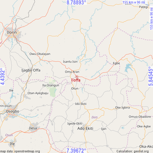
Iloffa GPS coordinates[2]
8° 5' 36.348" North, 5° 8' 32.388" East
| Map corner | latitude | longitude |
|---|---|---|
| Upper-left | 8.78893°, | 4.4392° |
| Center: | 8.09343°, | 5.14233° |
| Lower-right: | 7.39672°, | 5.84545° |
| Map W x H: | 154.8×154.8 km | = 96.2×96.2mi |
| max Lat: | 13.7543° ⇑52% North |
| Iloffa: | 8.09343° |
| min Lat: | ⇓48% South 4.31231° |
| min Long | Iloffa | max Long |
| 2.73333° | 5.14233° | 14.46552° |
| W 20.6%⇐ | ⇒79.4% E |
Elevation
Elevation of Iloffa is 568 m = 1864 ft, and this is 271.5 m = 891 ft above average elevation for this country.
| Max E: |
1599 m = 5246 ft | 9.2% |
| Iloffa | 568 m 1864 ft | |
| Avg. | 296.5 m = 973 ft | |
Min E: |
2 m = 7 ft | 90.8% |
See also: Nigeria elevation on elevation.city.
Geographical zone
Iloffa is located in North Torrid zone (between Equator and Tropic of Cancer). Distance of Equator is 899.9 km =559.2 mi to South.| Distance of | km | miles | from Iloffa |
|---|---|---|---|
| North Pole | 9107.2 | 5658.9 | to North |
| Arctic Circle | 6501.3 | 4039.7 | to North |
| Tropic Cancer | 1706 | 1060.1 | to North |
| Equator | 899.9 | 559.2 | to South |


Nearby cities:
15 places around Iloffa: (largest is in red/bold)
• Ajasse Ipo
39.1 km =24.3 mi,  293°
293°
• Araromi-Opin
12.7 km =7.9 mi,  104°
104°
• Ido-Ekiti
27.9 km =17.3 mi,  170°
170°
• Ifaki
35.8 km =22.2 mi,  160°
160°
• Ijero-Ekiti
32 km =19.9 mi,  194°
194°
• Ila Orangun
27.6 km =17.1 mi,  252°
252°
• Ipoti
25.5 km =15.8 mi,  196°
196°
• Iye-Ekiti
18.4 km =11.4 mi,  147°
147°
• Oke Ila
23.7 km =14.7 mi,  227°
227°
• Oke Mesi
39.6 km =24.6 mi,  218°
218°
• Omu-Aran
6.7 km =4.2 mi,  318°
318°
• Otun-Ekiti
11.9 km =7.4 mi, 190°
• Owu-Isin
24.9 km =15.5 mi,  327°
327°
• Oyan
41.6 km =25.8 mi,  263°
263°
• Oye-Ekiti
38.8 km =24.1 mi, 147°
Sources, notices
• [Note1] Compared only with cities in Nigeria existing in our database
• [Src1] Map data: © OpenStreetMap contributors (CC-BY-SA)
• [Src2] Other city data from geonames.org with taken over terms of usage.
• [Src3] Geographical zone / Annual Mean Temperature by Robert A. Rohde @ Wikipedia
