Omu-Aran geodata
Omu-Aran (Kwara) is a seat of a second-order administrative division; located in Nigeria in Africa/Lagos (GMT+1) time zone. With population of 14,477 people, there are 248 cities with bigger population in this country. Compared to other cities in Nigeria, 51.4% of cities are located further ↑North; 80.3% of cities are located further →East and 90.1% of cities have lower elevation than Omu-Aran. Note1


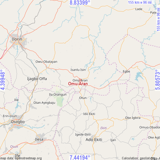
Omu-Aran GPS coordinates[2]
8° 8' 18.852" North, 5° 6' 9.36" East
| Map corner | latitude | longitude |
|---|---|---|
| Upper-left | 8.83399°, | 4.39948° |
| Center: | 8.13857°, | 5.1026° |
| Lower-right: | 7.44194°, | 5.80573° |
| Map W x H: | 154.8×154.8 km | = 96.2×96.2mi |
| max Lat: | 13.7543° ⇑51.4% North |
| Omu-Aran: | 8.13857° |
| min Lat: | ⇓48.6% South 4.31231° |
| min Long | Omu-Aran | max Long |
| 2.73333° | 5.1026° | 14.46552° |
| W 19.7%⇐ | ⇒80.3% E |
Elevation
Elevation of Omu-Aran is 556 m = 1824 ft, and this is 259.5 m = 851 ft above average elevation for this country.
| Max E: |
1599 m = 5246 ft | 9.9% |
| Omu-Aran | 556 m 1824 ft | |
| Avg. | 296.5 m = 973 ft | |
Min E: |
2 m = 7 ft | 90.1% |
See also: Nigeria elevation on elevation.city.
Geographical zone
Omu-Aran is located in North Torrid zone (between Equator and Tropic of Cancer). Distance of Equator is 904.9 km =562.3 mi to South.| Distance of | km | miles | from Omu-Aran |
|---|---|---|---|
| North Pole | 9102.1 | 5655.8 | to North |
| Arctic Circle | 6496.2 | 4036.6 | to North |
| Tropic Cancer | 1701 | 1057 | to North |
| Equator | 904.9 | 562.3 | to South |


Nearby cities:
15 places around Omu-Aran: (largest is in red/bold)
• Ajasse Ipo
33.2 km =20.6 mi,  288°
288°
• Araromi-Opin
18.6 km =11.6 mi,  116°
116°
• Ido-Ekiti
33.7 km =20.9 mi,  164°
164°
• Ifaki
42 km =26.1 mi, 157°
• Ijero-Ekiti
36.2 km =22.5 mi,  186°
186°
• Ila Orangun
25.7 km =16 mi,  238°
238°
• Iloffa
6.7 km =4.2 mi,  138°
138°
• Ipoti
29.6 km =18.4 mi, 185°
• Iye-Ekiti
25 km =15.5 mi, 144°
• Oke Ila
24.7 km =15.3 mi,  212°
212°
• Oke Mesi
41.2 km =25.6 mi, 209°
• Otan Ayegbaju
40.6 km =25.2 mi, 238°
• Otun-Ekiti
16.8 km =10.4 mi,  172°
172°
• Owu-Isin
18.3 km =11.4 mi,  329°
329°
• Oyan
38.3 km =23.8 mi,  255°
255°
Sources, notices
• [Note1] Compared only with cities in Nigeria existing in our database
• [Src1] Map data: © OpenStreetMap contributors (CC-BY-SA)
• [Src2] Other city data from geonames.org with taken over terms of usage.
• [Src3] Geographical zone / Annual Mean Temperature by Robert A. Rohde @ Wikipedia
