Ila Orangun geodata
Ila Orangun (Osun) is a seat of a second-order administrative division; located in Nigeria in Africa/Lagos (GMT+1) time zone. With population of 179,192 people, there are 48 cities with bigger population in this country. Compared to other cities in Nigeria, 52.8% of cities are located further ↑North; 82.5% of cities are located further →East and 83.9% of cities have lower elevation than Ila Orangun. Note1


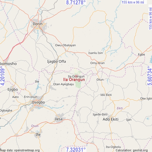
Ila Orangun GPS coordinates[2]
8° 1' 1.704" North, 4° 54' 15.156" East
| Map corner | latitude | longitude |
|---|---|---|
| Upper-left | 8.71278°, | 4.20109° |
| Center: | 8.01714°, | 4.90421° |
| Lower-right: | 7.32031°, | 5.60734° |
| Map W x H: | 154.8×154.8 km | = 96.2×96.2mi |
| max Lat: | 13.7543° ⇑52.8% North |
| Ila Orangun: | 8.01714° |
| min Lat: | ⇓47.2% South 4.31231° |
| min Long | Ila Orangun | max Long |
| 2.73333° | 4.90421° | 14.46552° |
| W 17.5%⇐ | ⇒82.5% E |
Elevation
Elevation of Ila Orangun is 493 m = 1617 ft, and this is 196.5 m = 645 ft above average elevation for this country.
| Max E: |
1599 m = 5246 ft | 16.1% |
| Ila Orangun | 493 m 1617 ft | |
| Avg. | 296.5 m = 973 ft | |
Min E: |
2 m = 7 ft | 83.9% |
See also: Ila Orangun elevation on elevation.city.
Geographical zone
Ila Orangun is located in North Torrid zone (between Equator and Tropic of Cancer). Distance of Equator is 891.4 km =553.9 mi to South.| Distance of | km | miles | from Ila Orangun |
|---|---|---|---|
| North Pole | 9115.6 | 5664.2 | to North |
| Arctic Circle | 6509.8 | 4045 | to North |
| Tropic Cancer | 1714.5 | 1065.3 | to North |
| Equator | 891.4 | 553.9 | to South |


Nearby cities:
15 places around Ila Orangun: (largest is in red/bold)
• Ajasse Ipo
25.9 km =16.1 mi,  338°
338°
• Ijero-Ekiti
28.7 km =17.8 mi,  141°
141°
• Ikirun
28.5 km =17.7 mi,  246°
246°
• Ilemona
28.7 km =17.8 mi,  291°
291°
• Iloffa
27.6 km =17.1 mi,  72°
72°
• Ipoti
24.8 km =15.4 mi,  129°
129°
• Iragbiji
27 km =16.8 mi,  242°
242°
• Offa
25 km =15.5 mi,  305°
305°
• Oke Ila
11.5 km =7.1 mi, 130°
• Oke Mesi
22.3 km =13.9 mi,  176°
176°
• Okuku
25.5 km =15.8 mi,  270°
270°
• Omu-Aran
25.7 km =16 mi,  58°
58°
• Otan Ayegbaju
14.9 km =9.3 mi, 238°
• Otun-Ekiti
24.3 km =15.1 mi,  97°
97°
• Oyan
15.6 km =9.7 mi,  283°
283°
Sources, notices
• [Note1] Compared only with cities in Nigeria existing in our database
• [Src1] Map data: © OpenStreetMap contributors (CC-BY-SA)
• [Src2] Other city data from geonames.org with taken over terms of usage.
• [Src3] Geographical zone / Annual Mean Temperature by Robert A. Rohde @ Wikipedia
