Otun-Ekiti geodata
Otun-Ekiti (Ekiti) is a seat of a second-order administrative division; located in Nigeria in Africa/Lagos (GMT+1) time zone. In our database, there are 451 cities with bigger population. Compared to other cities in Nigeria, 53.1% of cities are located further ↑North; 79.7% of cities are located further →East and 88.3% of cities have lower elevation than Otun-Ekiti. Note1


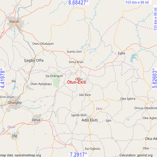
Otun-Ekiti GPS coordinates[2]
7° 59' 18.888" North, 5° 7' 22.476" East
| Map corner | latitude | longitude |
|---|---|---|
| Upper-left | 8.68427°, | 4.41978° |
| Center: | 7.98858°, | 5.12291° |
| Lower-right: | 7.2917°, | 5.82603° |
| Map W x H: | 154.8×154.8 km | = 96.2×96.2mi |
| max Lat: | 13.7543° ⇑53.1% North |
| Otun-Ekiti: | 7.98858° |
| min Lat: | ⇓46.9% South 4.31231° |
| min Long | Otun-Ekiti | max Long |
| 2.73333° | 5.12291° | 14.46552° |
| W 20.3%⇐ | ⇒79.7% E |
Elevation
Elevation of Otun-Ekiti is 535 m = 1755 ft, and this is 238.5 m = 782 ft above average elevation for this country.
| Max E: |
1599 m = 5246 ft | 11.7% |
| Otun-Ekiti | 535 m 1755 ft | |
| Avg. | 296.5 m = 973 ft | |
Min E: |
2 m = 7 ft | 88.3% |
See also: Nigeria elevation on elevation.city.
Geographical zone
Otun-Ekiti is located in North Torrid zone (between Equator and Tropic of Cancer). Distance of Equator is 888.2 km =551.9 mi to South.| Distance of | km | miles | from Otun-Ekiti |
|---|---|---|---|
| North Pole | 9118.8 | 5666.2 | to North |
| Arctic Circle | 6512.9 | 4046.9 | to North |
| Tropic Cancer | 1717.7 | 1067.3 | to North |
| Equator | 888.2 | 551.9 | to South |


Nearby cities:
15 places around Otun-Ekiti: (largest is in red/bold)
• Aramoko-Ekiti
32.8 km =20.4 mi,  196°
196°
• Araromi-Opin
16.8 km =10.4 mi,  59°
59°
• Ido-Ekiti
17.2 km =10.7 mi,  157°
157°
• Ifaki
26.1 km =16.2 mi,  148°
148°
• Igede-Ekiti
35.6 km =22.1 mi,  179°
179°
• Ijero-Ekiti
20.2 km =12.6 mi, 197°
• Ila Orangun
24.3 km =15.1 mi,  277°
277°
• Iloffa
11.9 km =7.4 mi,  10°
10°
• Ipoti
13.7 km =8.5 mi, 201°
• Iye-Ekiti
12.7 km =7.9 mi,  107°
107°
• Oke Ila
16 km =9.9 mi,  254°
254°
• Oke Mesi
29.7 km =18.5 mi,  229°
229°
• Omu-Aran
16.8 km =10.4 mi,  352°
352°
• Owu-Isin
34.4 km =21.4 mi,  340°
340°
• Oye-Ekiti
31.2 km =19.4 mi,  132°
132°
Sources, notices
• [Note1] Compared only with cities in Nigeria existing in our database
• [Src1] Map data: © OpenStreetMap contributors (CC-BY-SA)
• [Src2] Other city data from geonames.org with taken over terms of usage.
• [Src3] Geographical zone / Annual Mean Temperature by Robert A. Rohde @ Wikipedia
