Oke Ila geodata
Oke Ila (Ekiti) is a populated place; located in Nigeria in Africa/Lagos (GMT+1) time zone. With population of 35,000 people, there are 160 cities with bigger population in this country. Compared to other cities in Nigeria, 53.5% of cities are located further ↑North; 81.5% of cities are located further →East and 89% of cities have lower elevation than Oke Ila. Note1


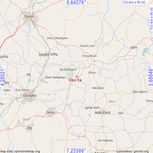
Oke Ila GPS coordinates[2]
7° 57' 0" North, 4° 58' 59.988" East
| Map corner | latitude | longitude |
|---|---|---|
| Upper-left | 8.64576°, | 4.28021° |
| Center: | 7.95°, | 4.98333° |
| Lower-right: | 7.25306°, | 5.68646° |
| Map W x H: | 154.9×154.9 km | = 96.3×96.3mi |
| max Lat: | 13.7543° ⇑53.5% North |
| Oke Ila: | 7.95° |
| min Lat: | ⇓46.5% South 4.31231° |
| min Long | Oke Ila | max Long |
| 2.73333° | 4.98333° | 14.46552° |
| W 18.5%⇐ | ⇒81.5% E |
Elevation
Elevation of Oke Ila is 540 m = 1772 ft, and this is 243.5 m = 799 ft above average elevation for this country.
| Max E: |
1599 m = 5246 ft | 11% |
| Oke Ila | 540 m 1772 ft | |
| Avg. | 296.5 m = 973 ft | |
Min E: |
2 m = 7 ft | 89% |
See also: Nigeria elevation on elevation.city.
Geographical zone
Oke Ila is located in North Torrid zone (between Equator and Tropic of Cancer). Distance of Equator is 884 km =549.3 mi to South.| Distance of | km | miles | from Oke Ila |
|---|---|---|---|
| North Pole | 9123.1 | 5668.8 | to North |
| Arctic Circle | 6517.2 | 4049.6 | to North |
| Tropic Cancer | 1722 | 1070 | to North |
| Equator | 884 | 549.3 | to South |


Nearby cities:
15 places around Oke Ila: (largest is in red/bold)
• Aramoko-Ekiti
28 km =17.4 mi,  166°
166°
• Araromi-Opin
32.4 km =20.1 mi,  66°
66°
• Efon-Alaaye
33.3 km =20.7 mi,  191°
191°
• Ido-Ekiti
24.9 km =15.5 mi,  117°
117°
• Ijero-Ekiti
17.6 km =10.9 mi,  148°
148°
• Ila Orangun
11.5 km =7.1 mi,  310°
310°
• Iloffa
23.7 km =14.7 mi,  47°
47°
• Ipoti
13.3 km =8.3 mi,  129°
129°
• Iragbiji
33 km =20.5 mi,  261°
261°
• Iye-Ekiti
27.5 km =17.1 mi,  88°
88°
• Oke Mesi
16.5 km =10.3 mi,  206°
206°
• Omu-Aran
24.7 km =15.3 mi,  32°
32°
• Otan Ayegbaju
21.5 km =13.4 mi,  269°
269°
• Otun-Ekiti
16 km =9.9 mi, 74°
• Oyan
26.3 km =16.3 mi,  294°
294°
Sources, notices
• [Note1] Compared only with cities in Nigeria existing in our database
• [Src1] Map data: © OpenStreetMap contributors (CC-BY-SA)
• [Src2] Other city data from geonames.org with taken over terms of usage.
• [Src3] Geographical zone / Annual Mean Temperature by Robert A. Rohde @ Wikipedia
