Akwukwu-Igbo geodata
Akwukwu-Igbo (Delta) is a seat of a second-order administrative division; located in Nigeria in Africa/Lagos (GMT+1) time zone. In our database, there are 451 cities with bigger population. Compared to other cities in Nigeria, 79% of cities are located further ↑North; 63.4% of cities are located further →East and 62.5% of cities have higher elevation than Akwukwu-Igbo. Note1


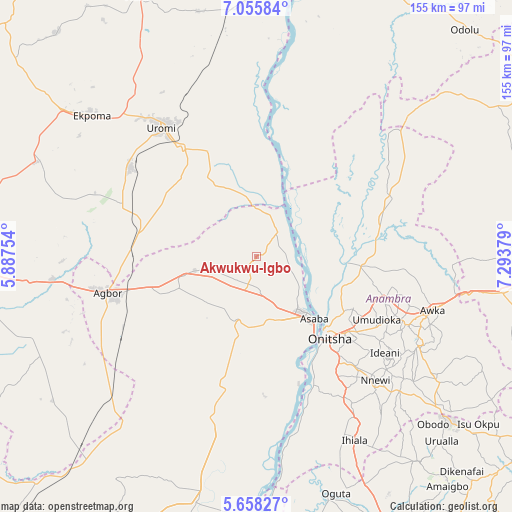
Akwukwu-Igbo GPS coordinates[2]
6° 21' 27.108" North, 6° 35' 26.376" East
| Map corner | latitude | longitude |
|---|---|---|
| Upper-left | 7.05584°, | 5.88754° |
| Center: | 6.35753°, | 6.59066° |
| Lower-right: | 5.65827°, | 7.29379° |
| Map W x H: | 155.4×155.4 km | = 96.6×96.6mi |
| max Lat: | 13.7543° ⇑79% North |
| Akwukwu-Igbo: | 6.35753° |
| min Lat: | ⇓21% South 4.31231° |
| min Long | Akwukwu-Igbo | max Long |
| 2.73333° | 6.59066° | 14.46552° |
| W 36.6%⇐ | ⇒63.4% E |
Elevation
Elevation of Akwukwu-Igbo is 191 m = 627 ft, and this is 105.5 m = 346 ft below average elevation for this country.
| Max E: |
1599 m = 5246 ft | 62.5% |
| Avg. | 296.5 m = 973 ft | |
| Akwukwu-Igbo | 191 m = 627 ft | |
Min E: |
2 m = 7 ft | 37.5% |
See also: Nigeria elevation on elevation.city.
Geographical zone
Akwukwu-Igbo is located in North Torrid zone (between Equator and Tropic of Cancer). Distance of Equator is 706.9 km =439.2 mi to South.| Distance of | km | miles | from Akwukwu-Igbo |
|---|---|---|---|
| North Pole | 9300.2 | 5778.9 | to North |
| Arctic Circle | 6694.3 | 4159.6 | to North |
| Tropic Cancer | 1899 | 1180 | to North |
| Equator | 706.9 | 439.2 | to South |


Nearby cities:
15 places around Akwukwu-Igbo: (largest is in red/bold)
• Achalla
44.1 km =27.4 mi,  93°
93°
• Anaku
39.4 km =24.5 mi,  71°
71°
• Asaba
23.6 km =14.7 mi,  138°
138°
• Atani
42.1 km =26.2 mi,  155°
155°
• Illushi
35 km =21.7 mi,  6°
6°
• Issele-Uku
13.5 km =8.4 mi,  249°
249°
• Nkpor
35.1 km =21.8 mi,  130°
130°
• Nteje
37.8 km =23.5 mi,  105°
105°
• Nzam
18.6 km =11.6 mi,  55°
55°
• Ogidi
37.8 km =23.5 mi, 127°
• Ogwashi-Uku
21.2 km =13.2 mi,  200°
200°
• Onitsha
31.6 km =19.6 mi, 136°
• Otuocha
28.3 km =17.6 mi, 94°
• Ubiaja
40.2 km =25 mi,  325°
325°
• Umunede
32.7 km =20.3 mi, 251°
Sources, notices
• [Note1] Compared only with cities in Nigeria existing in our database
• [Src1] Map data: © OpenStreetMap contributors (CC-BY-SA)
• [Src2] Other city data from geonames.org with taken over terms of usage.
• [Src3] Geographical zone / Annual Mean Temperature by Robert A. Rohde @ Wikipedia
