Ogwashi-Uku geodata
Ogwashi-Uku (Delta) is a seat of a second-order administrative division; located in Nigeria in Africa/Lagos (GMT+1) time zone. With population of 26,137 people, there are 172 cities with bigger population in this country. Compared to other cities in Nigeria, 81.5% of cities are located further ↑North; 64.3% of cities are located further →East and 61.4% of cities have higher elevation than Ogwashi-Uku. Note1


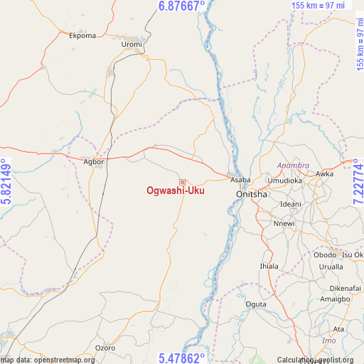
Ogwashi-Uku GPS coordinates[2]
6° 10' 41.196" North, 6° 31' 28.596" East
| Map corner | latitude | longitude |
|---|---|---|
| Upper-left | 6.87667°, | 5.82149° |
| Center: | 6.17811°, | 6.52461° |
| Lower-right: | 5.47862°, | 7.22774° |
| Map W x H: | 155.4×155.5 km | = 96.6×96.6mi |
| max Lat: | 13.7543° ⇑81.5% North |
| Ogwashi-Uku: | 6.17811° |
| min Lat: | ⇓18.5% South 4.31231° |
| min Long | Ogwashi-Uku | max Long |
| 2.73333° | 6.52461° | 14.46552° |
| W 35.7%⇐ | ⇒64.3% E |
Elevation
Elevation of Ogwashi-Uku is 198 m = 650 ft, and this is 98.5 m = 323 ft below average elevation for this country.
| Max E: |
1599 m = 5246 ft | 61.4% |
| Avg. | 296.5 m = 973 ft | |
| Ogwashi-Uku | 198 m = 650 ft | |
Min E: |
2 m = 7 ft | 38.6% |
See also: Nigeria elevation on elevation.city.
Geographical zone
Ogwashi-Uku is located in North Torrid zone (between Equator and Tropic of Cancer). Distance of Equator is 686.9 km =426.8 mi to South.| Distance of | km | miles | from Ogwashi-Uku |
|---|---|---|---|
| North Pole | 9320.1 | 5791.2 | to North |
| Arctic Circle | 6714.2 | 4172 | to North |
| Tropic Cancer | 1919 | 1192.4 | to North |
| Equator | 686.9 | 426.8 | to South |


Nearby cities:
15 places around Ogwashi-Uku: (largest is in red/bold)
• Agbor
37.5 km =23.3 mi,  282°
282°
• Akwukwu-Igbo
21.2 km =13.2 mi,  20°
20°
• Asaba
23 km =14.3 mi,  84°
84°
• Atani
30.8 km =19.1 mi,  126°
126°
• Issele-Uku
16.2 km =10.1 mi,  340°
340°
• Nkpor
33.9 km =21.1 mi,  95°
95°
• Nteje
44.9 km =27.9 mi, 77°
• Nzam
38 km =23.6 mi,  36°
36°
• Ogidi
37.6 km =23.4 mi,  94°
94°
• Ojoto
39.5 km =24.5 mi,  109°
109°
• Onitsha
29 km =18 mi, 96°
• Otuocha
39.8 km =24.7 mi,  63°
63°
• Owa-Oyibu
36 km =22.4 mi,  270°
270°
• Ozubulu
43.8 km =27.2 mi,  124°
124°
• Umunede
25.7 km =16 mi,  292°
292°
Sources, notices
• [Note1] Compared only with cities in Nigeria existing in our database
• [Src1] Map data: © OpenStreetMap contributors (CC-BY-SA)
• [Src2] Other city data from geonames.org with taken over terms of usage.
• [Src3] Geographical zone / Annual Mean Temperature by Robert A. Rohde @ Wikipedia
