Ubiaja geodata
Ubiaja (Edo) is a seat of a second-order administrative division; located in Nigeria in Africa/Lagos (GMT+1) time zone. With population of 21,782 people, there are 189 cities with bigger population in this country. Compared to other cities in Nigeria, 73.6% of cities are located further ↑North; 66% of cities are located further →East and 50.1% of cities have lower elevation than Ubiaja. Note1


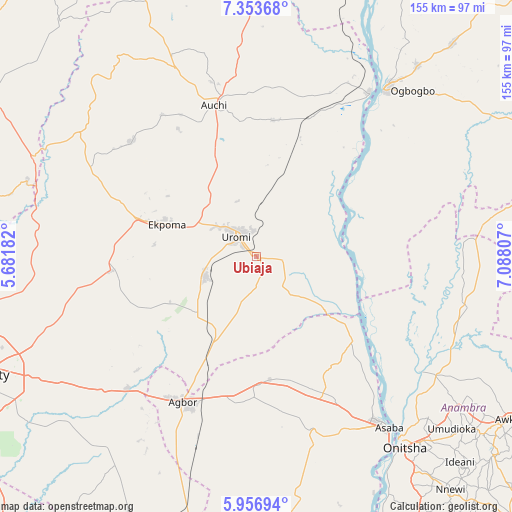
Ubiaja GPS coordinates[2]
6° 39' 20.916" North, 6° 23' 5.784" East
| Map corner | latitude | longitude |
|---|---|---|
| Upper-left | 7.35368°, | 5.68182° |
| Center: | 6.65581°, | 6.38494° |
| Lower-right: | 5.95694°, | 7.08807° |
| Map W x H: | 155.3×155.3 km | = 96.5×96.5mi |
| max Lat: | 13.7543° ⇑73.6% North |
| Ubiaja: | 6.65581° |
| min Lat: | ⇓26.4% South 4.31231° |
| min Long | Ubiaja | max Long |
| 2.73333° | 6.38494° | 14.46552° |
| W 34%⇐ | ⇒66% E |
Elevation
Elevation of Ubiaja is 286 m = 938 ft, and this is 10.5 m = 34 ft below average elevation for this country.
| Max E: |
1599 m = 5246 ft | 49.9% |
| Avg. | 296.5 m = 973 ft | |
| Ubiaja | 286 m = 938 ft | |
Min E: |
2 m = 7 ft | 50.1% |
See also: Nigeria elevation on elevation.city.
Geographical zone
Ubiaja is located in North Torrid zone (between Equator and Tropic of Cancer). Distance of Equator is 740.1 km =459.9 mi to South.| Distance of | km | miles | from Ubiaja |
|---|---|---|---|
| North Pole | 9267 | 5758.2 | to North |
| Arctic Circle | 6661.1 | 4139 | to North |
| Tropic Cancer | 1865.9 | 1159.4 | to North |
| Equator | 740.1 | 459.9 | to South |


Nearby cities:
15 places around Ubiaja: (largest is in red/bold)
• Afuze
51.4 km =31.9 mi,  312°
312°
• Agbor
49.4 km =30.7 mi,  205°
205°
• Akwukwu-Igbo
40.2 km =25 mi,  145°
145°
• Auchi
47.7 km =29.6 mi,  343°
343°
• Ehor
44.7 km =27.8 mi,  264°
264°
• Ekpoma
28.7 km =17.8 mi,  289°
289°
• Fugar
50 km =31.1 mi,  14°
14°
• Igueben
16.8 km =10.4 mi,  249°
249°
• Illushi
27 km =16.8 mi,  86°
86°
• Irrua
20.3 km =12.6 mi,  296°
296°
• Issele-Uku
39.1 km =24.3 mi,  165°
165°
• Nzam
44.2 km =27.5 mi,  120°
120°
• Onyedega
40.8 km =25.4 mi,  51°
51°
• Umunede
44.2 km =27.5 mi,  190°
190°
• Uromi
7.5 km =4.7 mi, 310°
Sources, notices
• [Note1] Compared only with cities in Nigeria existing in our database
• [Src1] Map data: © OpenStreetMap contributors (CC-BY-SA)
• [Src2] Other city data from geonames.org with taken over terms of usage.
• [Src3] Geographical zone / Annual Mean Temperature by Robert A. Rohde @ Wikipedia
