Asaba geodata
Asaba (Delta) is a seat of a first-order administrative division; located in Nigeria in Africa/Lagos (GMT+1) time zone. With population of 73,374 people, there are 127 cities with bigger population in this country. Compared to other cities in Nigeria, 81.2% of cities are located further ↑North; 62.1% of cities are located further →East and 87.7% of cities have higher elevation than Asaba. Note1


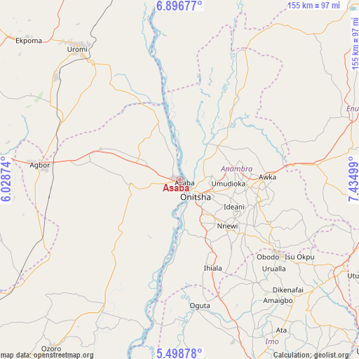
Asaba GPS coordinates[2]
6° 11' 53.664" North, 6° 43' 54.732" East
| Map corner | latitude | longitude |
|---|---|---|
| Upper-left | 6.89677°, | 6.02874° |
| Center: | 6.19824°, | 6.73187° |
| Lower-right: | 5.49878°, | 7.43499° |
| Map W x H: | 155.4×155.4 km | = 96.6×96.6mi |
| max Lat: | 13.7543° ⇑81.2% North |
| Asaba: | 6.19824° |
| min Lat: | ⇓18.8% South 4.31231° |
| min Long | Asaba | max Long |
| 2.73333° | 6.73187° | 14.46552° |
| W 37.9%⇐ | ⇒62.1% E |
Elevation
Elevation of Asaba is 46 m = 151 ft, and this is 250.5 m = 822 ft below average elevation for this country.
| Max E: |
1599 m = 5246 ft | 87.7% |
| Avg. | 296.5 m = 973 ft | |
| Asaba | 46 m = 151 ft | |
Min E: |
2 m = 7 ft | 12.3% |
See also: Asaba elevation on elevation.city.
Geographical zone
Asaba is located in North Torrid zone (between Equator and Tropic of Cancer). Distance of Equator is 689.2 km =428.2 mi to South.| Distance of | km | miles | from Asaba |
|---|---|---|---|
| North Pole | 9317.9 | 5789.9 | to North |
| Arctic Circle | 6712 | 4170.6 | to North |
| Tropic Cancer | 1916.7 | 1191 | to North |
| Equator | 689.2 | 428.2 | to South |


Nearby cities:
15 places around Asaba: (largest is in red/bold)
• Abagana
28.9 km =18 mi,  91°
91°
• Akwukwu-Igbo
23.6 km =14.7 mi,  318°
318°
• Atani
20.7 km =12.9 mi,  175°
175°
• Enugu-Ukwu
30.4 km =18.9 mi,  95°
95°
• Nkpor
12.1 km =7.5 mi,  116°
116°
• Nnewi
28.5 km =17.7 mi,  134°
134°
• Nteje
22.3 km =13.9 mi,  69°
69°
• Nzam
28.3 km =17.6 mi,  359°
359°
• Ogidi
15.4 km =9.6 mi,  109°
109°
• Ogwashi-Uku
23 km =14.3 mi,  264°
264°
• Ojoto
21.1 km =13.1 mi,  137°
137°
• Onitsha
8 km =5 mi, 132°
• Otuocha
20.1 km =12.5 mi,  38°
38°
• Ozubulu
29.9 km =18.6 mi,  153°
153°
• Ukpo
26 km =16.2 mi, 86°
Sources, notices
• [Note1] Compared only with cities in Nigeria existing in our database
• [Src1] Map data: © OpenStreetMap contributors (CC-BY-SA)
• [Src2] Other city data from geonames.org with taken over terms of usage.
• [Src3] Geographical zone / Annual Mean Temperature by Robert A. Rohde @ Wikipedia
