Waspán geodata
Waspán (North Caribbean Coast) is a seat of a second-order administrative division; located in Nicaragua in America/Managua (GMT-6) time zone. With population of 6,403 people, there are 64 cities with bigger population in this country. Compared to other cities in Nicaragua, 100% of cities are located further ↓South; 95.2% of cities are located further ←West and 87.4% of cities have higher elevation than Waspán. Note1


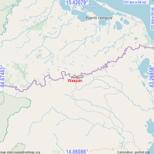
Waspán GPS coordinates[2]
14° 44' 30.804" North, 83° 58' 18.12" West
| Map corner | latitude | longitude |
|---|---|---|
| Upper-left | 15.42079°, | -84.67483° |
| Center: | 14.74189°, | -83.9717° |
| Lower-right: | 14.06086°, | -83.26858° |
| Map W x H: | 151.2×151.2 km | = 94×94mi |
| max Lat: | 14.74189° ⇑0% North |
| Waspán: | 14.74189° |
| min Lat: | ⇓100% South 10.94684° |
| min Long | Waspán | max Long |
| -87.4516° | -83.9717° | -83.06145° |
| W 95.2%⇐ | ⇒4.8% E |
Elevation
Elevation of Waspán is 46 m = 151 ft, and this is 291.2 m = 955 ft below average elevation for this country.
| Max E: |
1288 m = 4226 ft | 87.4% |
| Avg. | 337.2 m = 1106 ft | |
| Waspán | 46 m = 151 ft | |
Min E: |
1 m = 3 ft | 12.6% |
See also: Nicaragua elevation on elevation.city.
Geographical zone
Waspán is located in North Torrid zone (between Equator and Tropic of Cancer). Distance of this Northern Tropic circle is 966.8 km =600.7 mi to North.| Distance of | km | miles | from Waspán |
|---|---|---|---|
| North Pole | 8367.9 | 5199.6 | to North |
| Arctic Circle | 5762 | 3580.3 | to North |
| Tropic Cancer | 966.8 | 600.7 | to North |
| Equator | 1639.1 | 1018.5 | to South |


Nearby cities:
15 places around Waspán: (largest is in red/bold)
• Bocay
136.3 km =84.7 mi,  248°
248°
• Bonanza
103.6 km =64.4 mi,  220°
220°
• El Tortuguero
214.8 km =133.5 mi,  186°
186°
• Karawala
205.8 km =127.9 mi,  168°
168°
• La Cruz de Río Grande
182.6 km =113.5 mi, 187°
• Mulukukú
203.9 km =126.7 mi,  211°
211°
• Prinzapolka
154.8 km =96.2 mi,  163°
163°
• Puerto Cabezas
100.6 km =62.5 mi,  141°
141°
• San José de Bocay
215.3 km =133.8 mi,  231°
231°
• Siuna
141.8 km =88.1 mi, 217°
• Waslala
217.3 km =135 mi, 223°
• Waslala
226.6 km =140.8 mi, 222°
• Wiwili
235.6 km =146.4 mi,  237°
237°
• Wiwilí
235.2 km =146.1 mi, 238°
• Wiwilí de Jinotega
235.1 km =146.1 mi, 237°
Sources, notices
• [Note1] Compared only with cities in Nicaragua existing in our database
• [Src1] Map data: © OpenStreetMap contributors (CC-BY-SA)
• [Src2] Other city data from geonames.org with taken over terms of usage.
• [Src3] Geographical zone / Annual Mean Temperature by Robert A. Rohde @ Wikipedia
