Puerto Cabezas geodata
Puerto Cabezas (North Caribbean Coast) is a seat of a first-order administrative division; located in Nicaragua in America/Managua (GMT-6) time zone. With population of 33,635 people, there are 16 cities with bigger population in this country. Compared to other cities in Nicaragua, 98.8% of cities are located further ↓South; 99.4% of cities are located further ←West and 98.8% of cities have higher elevation than Puerto Cabezas. Note1


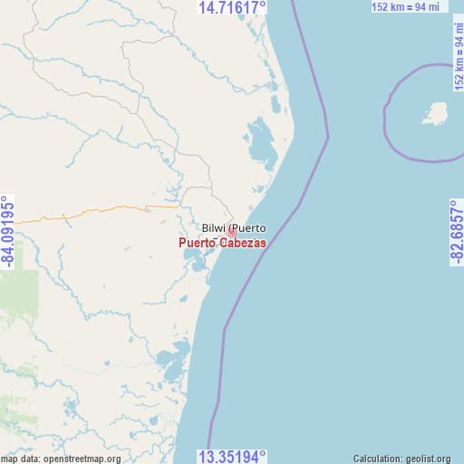
Puerto Cabezas GPS coordinates[2]
14° 2' 6.252" North, 83° 23' 19.752" West
| Map corner | latitude | longitude |
|---|---|---|
| Upper-left | 14.71617°, | -84.09195° |
| Center: | 14.03507°, | -83.38882° |
| Lower-right: | 13.35194°, | -82.6857° |
| Map W x H: | 151.7×151.7 km | = 94.3×94.3mi |
| max Lat: | 14.74189° ⇑1.2% North |
| Puerto Cabezas: | 14.03507° |
| min Lat: | ⇓98.8% South 10.94684° |
| min Long | Puerto Cabezas | max Long |
| -87.4516° | -83.38882° | -83.06145° |
| W 99.4%⇐ | ⇒0.59999999999999% E |
Elevation
Elevation of Puerto Cabezas is 8 m = 26 ft, and this is 329.2 m = 1080 ft below average elevation for this country.
| Max E: |
1288 m = 4226 ft | 98.8% |
| Avg. | 337.2 m = 1106 ft | |
| Puerto Cabezas | 8 m = 26 ft | |
Min E: |
1 m = 3 ft | 1.2% |
See also: Nicaragua elevation on elevation.city.
Geographical zone
Puerto Cabezas is located in North Torrid zone (between Equator and Tropic of Cancer). Distance of this Northern Tropic circle is 1045.4 km =649.6 mi to North.| Distance of | km | miles | from Puerto Cabezas |
|---|---|---|---|
| North Pole | 8446.5 | 5248.4 | to North |
| Arctic Circle | 5840.6 | 3629.2 | to North |
| Tropic Cancer | 1045.4 | 649.6 | to North |
| Equator | 1560.6 | 969.7 | to South |


Nearby cities:
15 places around Puerto Cabezas: (largest is in red/bold)
• Bluefields
228.4 km =141.9 mi,  190°
190°
• Bocay
192.3 km =119.5 mi,  278°
278°
• Bonanza
129.7 km =80.6 mi,  269°
269°
• Corn Island
209.8 km =130.4 mi,  170°
170°
• El Rama
227.1 km =141.1 mi,  203°
203°
• El Tortuguero
160.6 km =99.8 mi,  212°
212°
• Karawala
124.5 km =77.4 mi, 189°
• Kukrahill
203.2 km =126.3 mi, 190°
• La Cruz de Río Grande
133.9 km =83.2 mi,  220°
220°
• Laguna de Perlas
190.6 km =118.4 mi, 189°
• Mulukukú
194.4 km =120.8 mi,  240°
240°
• Prinzapolka
72.4 km =45 mi, 195°
• Siuna
153.6 km =95.4 mi,  257°
257°
• Waslala
227.8 km =141.5 mi,  250°
250°
• Waspán
100.6 km =62.5 mi,  321°
321°
Sources, notices
• [Note1] Compared only with cities in Nicaragua existing in our database
• [Src1] Map data: © OpenStreetMap contributors (CC-BY-SA)
• [Src2] Other city data from geonames.org with taken over terms of usage.
• [Src3] Geographical zone / Annual Mean Temperature by Robert A. Rohde @ Wikipedia
