Tola geodata
Tola (Rivas) is a seat of a second-order administrative division; located in Nicaragua in America/Managua (GMT-6) time zone. With population of 2,638 people, there are 98 cities with bigger population in this country. Compared to other cities in Nicaragua, 95.2% of cities are located further ↑North; 58.1% of cities are located further ←West and 88% of cities have higher elevation than Tola. Note1


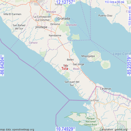
Tola GPS coordinates[2]
11° 26' 21.372" North, 85° 56' 20.076" West
| Map corner | latitude | longitude |
|---|---|---|
| Upper-left | 12.12757°, | -86.64204° |
| Center: | 11.43927°, | -85.93891° |
| Lower-right: | 10.74929°, | -85.23579° |
| Map W x H: | 153.3×153.3 km | = 95.3×95.3mi |
| max Lat: | 14.74189° ⇑95.2% North |
| Tola: | 11.43927° |
| min Lat: | ⇓4.8% South 10.94684° |
| min Long | Tola | max Long |
| -87.4516° | -85.93891° | -83.06145° |
| W 58.1%⇐ | ⇒41.9% E |
Elevation
Elevation of Tola is 44 m = 144 ft, and this is 293.2 m = 962 ft below average elevation for this country.
| Max E: |
1288 m = 4226 ft | 88% |
| Avg. | 337.2 m = 1106 ft | |
| Tola | 44 m = 144 ft | |
Min E: |
1 m = 3 ft | 12% |
See also: Nicaragua elevation on elevation.city.
Geographical zone
Tola is located in North Torrid zone (between Equator and Tropic of Cancer). Distance of Equator is 1271.9 km =790.3 mi to South.| Distance of | km | miles | from Tola |
|---|---|---|---|
| North Pole | 8735.1 | 5427.7 | to North |
| Arctic Circle | 6129.2 | 3808.5 | to North |
| Tropic Cancer | 1334 | 828.9 | to North |
| Equator | 1271.9 | 790.3 | to South |


Nearby cities:
15 places around Tola: (largest is in red/bold)
• Altagracia
41.7 km =25.9 mi,  70°
70°
• Belén
8.9 km =5.5 mi,  37°
37°
• Buenos Aires
13.7 km =8.5 mi,  75°
75°
• Diriomo
50.1 km =31.1 mi,  345°
345°
• El Rosario
50.2 km =31.2 mi,  330°
330°
• La Conquista
42.9 km =26.7 mi,  319°
319°
• La Paz de Carazo
47.4 km =29.5 mi, 334°
• Moyogalpa
28.5 km =17.7 mi, 66°
• Nandaime
37.4 km =23.2 mi,  340°
340°
• Potosí
10.8 km =6.7 mi,  55°
55°
• Rivas
12.3 km =7.6 mi,  91°
91°
• San Jorge
14.9 km =9.3 mi, 82°
• San Juan del Sur
22 km =13.7 mi,  160°
160°
• Santa Teresa
45.2 km =28.1 mi, 318°
• Santa Teresa
47.2 km =29.3 mi, 328°
Sources, notices
• [Note1] Compared only with cities in Nicaragua existing in our database
• [Src1] Map data: © OpenStreetMap contributors (CC-BY-SA)
• [Src2] Other city data from geonames.org with taken over terms of usage.
• [Src3] Geographical zone / Annual Mean Temperature by Robert A. Rohde @ Wikipedia
