Potosí geodata
Potosí (Rivas) is a seat of a second-order administrative division; located in Nicaragua in America/Managua (GMT-6) time zone. With population of 5,222 people, there are 73 cities with bigger population in this country. Compared to other cities in Nicaragua, 93.4% of cities are located further ↑North; 60.5% of cities are located further ←West and 78.4% of cities have higher elevation than Potosí. Note1


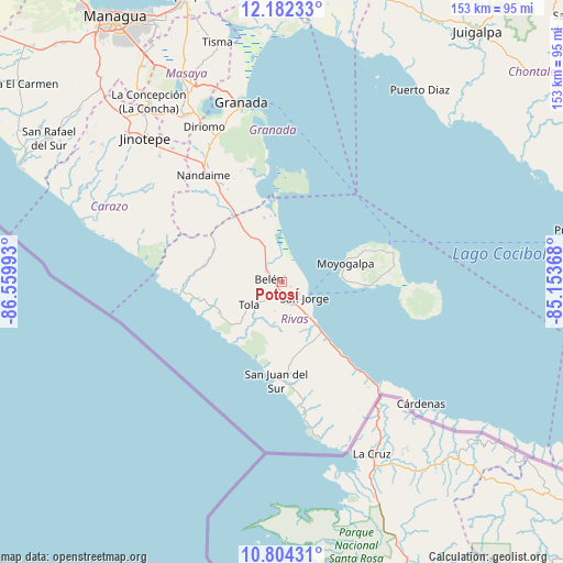
Potosí GPS coordinates[2]
11° 29' 38.976" North, 85° 51' 24.48" West
| Map corner | latitude | longitude |
|---|---|---|
| Upper-left | 12.18233°, | -86.55993° |
| Center: | 11.49416°, | -85.8568° |
| Lower-right: | 10.80431°, | -85.15368° |
| Map W x H: | 153.2×153.2 km | = 95.2×95.2mi |
| max Lat: | 14.74189° ⇑93.4% North |
| Potosí: | 11.49416° |
| min Lat: | ⇓6.6% South 10.94684° |
| min Long | Potosí | max Long |
| -87.4516° | -85.8568° | -83.06145° |
| W 60.5%⇐ | ⇒39.5% E |
Elevation
Elevation of Potosí is 63 m = 207 ft, and this is 274.2 m = 900 ft below average elevation for this country.
| Max E: |
1288 m = 4226 ft | 78.4% |
| Avg. | 337.2 m = 1106 ft | |
| Potosí | 63 m = 207 ft | |
Min E: |
1 m = 3 ft | 21.6% |
See also: Nicaragua elevation on elevation.city.
Geographical zone
Potosí is located in North Torrid zone (between Equator and Tropic of Cancer). Distance of Equator is 1278 km =794.1 mi to South.| Distance of | km | miles | from Potosí |
|---|---|---|---|
| North Pole | 8729 | 5423.9 | to North |
| Arctic Circle | 6123.1 | 3804.7 | to North |
| Tropic Cancer | 1327.9 | 825.1 | to North |
| Equator | 1278 | 794.1 | to South |


Nearby cities:
15 places around Potosí: (largest is in red/bold)
• Altagracia
31.4 km =19.5 mi,  75°
75°
• Belén
3.7 km =2.3 mi,  285°
285°
• Buenos Aires
5.2 km =3.2 mi,  122°
122°
• Diriomo
47.5 km =29.5 mi,  333°
333°
• Diriá
48.4 km =30.1 mi, 333°
• La Conquista
45.3 km =28.1 mi,  306°
306°
• La Paz de Carazo
47 km =29.2 mi,  321°
321°
• Moyogalpa
18 km =11.2 mi,  73°
73°
• Nandaime
36.2 km =22.5 mi, 323°
• Rivas
7.2 km =4.5 mi,  152°
152°
• San Jorge
7.2 km =4.5 mi,  126°
126°
• San Juan del Sur
26.9 km =16.7 mi,  183°
183°
• Santa Teresa
47.8 km =29.7 mi, 305°
• Santa Teresa
47.9 km =29.8 mi, 315°
• Tola
10.8 km =6.7 mi,  235°
235°
Sources, notices
• [Note1] Compared only with cities in Nicaragua existing in our database
• [Src1] Map data: © OpenStreetMap contributors (CC-BY-SA)
• [Src2] Other city data from geonames.org with taken over terms of usage.
• [Src3] Geographical zone / Annual Mean Temperature by Robert A. Rohde @ Wikipedia
