San Jorge geodata
San Jorge (Rivas) is a seat of a second-order administrative division; located in Nicaragua in America/Managua (GMT-6) time zone. With population of 7,158 people, there are 56 cities with bigger population in this country. Compared to other cities in Nicaragua, 94.6% of cities are located further ↑North; 65.9% of cities are located further ←West and 82% of cities have higher elevation than San Jorge. Note1


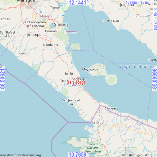
San Jorge GPS coordinates[2]
11° 27' 21.024" North, 85° 48' 11.088" West
| Map corner | latitude | longitude |
|---|---|---|
| Upper-left | 12.1441°, | -86.50621° |
| Center: | 11.45584°, | -85.80308° |
| Lower-right: | 10.7659°, | -85.09996° |
| Map W x H: | 153.2×153.2 km | = 95.2×95.2mi |
| max Lat: | 14.74189° ⇑94.6% North |
| San Jorge: | 11.45584° |
| min Lat: | ⇓5.4% South 10.94684° |
| min Long | San Jorge | max Long |
| -87.4516° | -85.80308° | -83.06145° |
| W 65.9%⇐ | ⇒34.1% E |
Elevation
Elevation of San Jorge is 54 m = 177 ft, and this is 283.2 m = 929 ft below average elevation for this country.
| Max E: |
1288 m = 4226 ft | 82% |
| Avg. | 337.2 m = 1106 ft | |
| San Jorge | 54 m = 177 ft | |
Min E: |
1 m = 3 ft | 18% |
See also: Nicaragua elevation on elevation.city.
Geographical zone
San Jorge is located in North Torrid zone (between Equator and Tropic of Cancer). Distance of Equator is 1273.8 km =791.5 mi to South.| Distance of | km | miles | from San Jorge |
|---|---|---|---|
| North Pole | 8733.3 | 5426.6 | to North |
| Arctic Circle | 6127.4 | 3807.4 | to North |
| Tropic Cancer | 1332.1 | 827.7 | to North |
| Equator | 1273.8 | 791.5 | to South |


Nearby cities:
15 places around San Jorge: (largest is in red/bold)
• Altagracia
27.4 km =17 mi,  63°
63°
• Belén
10.8 km =6.7 mi,  299°
299°
• Buenos Aires
2.1 km =1.3 mi,  315°
315°
• Cárdenas
43.1 km =26.8 mi,  131°
131°
• Diriomo
54 km =33.6 mi,  329°
329°
• La Conquista
52.5 km =32.6 mi,  306°
306°
• La Paz de Carazo
54 km =33.6 mi, 319°
• Moyogalpa
14.8 km =9.2 mi,  50°
50°
• Nandaime
43.1 km =26.8 mi, 320°
• Potosí
7.2 km =4.5 mi, 306°
• Rivas
3.3 km =2.1 mi,  230°
230°
• San Juan del Sur
23.7 km =14.7 mi,  198°
198°
• Santa Teresa
55 km =34.2 mi, 305°
• Santa Teresa
55 km =34.2 mi, 314°
• Tola
14.9 km =9.3 mi,  262°
262°
Sources, notices
• [Note1] Compared only with cities in Nicaragua existing in our database
• [Src1] Map data: © OpenStreetMap contributors (CC-BY-SA)
• [Src2] Other city data from geonames.org with taken over terms of usage.
• [Src3] Geographical zone / Annual Mean Temperature by Robert A. Rohde @ Wikipedia
