Pueblo Nuevo geodata
Pueblo Nuevo (Estelí) is a seat of a second-order administrative division; located in Nicaragua in America/Managua (GMT-6) time zone. With population of 4,608 people, there are 79 cities with bigger population in this country. Compared to other cities in Nicaragua, 82.6% of cities are located further ↓South; 77.8% of cities are located further →East and 82.6% of cities have lower elevation than Pueblo Nuevo. Note1


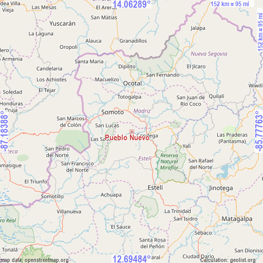
Pueblo Nuevo GPS coordinates[2]
13° 22' 47.424" North, 86° 28' 50.7" West
| Map corner | latitude | longitude |
|---|---|---|
| Upper-left | 14.06289°, | -87.18388° |
| Center: | 13.37984°, | -86.48075° |
| Lower-right: | 12.69484°, | -85.77763° |
| Map W x H: | 152.1×152.1 km | = 94.5×94.5mi |
| max Lat: | 14.74189° ⇑17.4% North |
| Pueblo Nuevo: | 13.37984° |
| min Lat: | ⇓82.6% South 10.94684° |
| min Long | Pueblo Nuevo | max Long |
| -87.4516° | -86.48075° | -83.06145° |
| W 22.2%⇐ | ⇒77.8% E |
Elevation
Elevation of Pueblo Nuevo is 612 m = 2008 ft, and this is 274.8 m = 902 ft above average elevation for this country.
| Max E: |
1288 m = 4226 ft | 17.4% |
| Pueblo Nuevo | 612 m 2008 ft | |
| Avg. | 337.2 m = 1106 ft | |
Min E: |
1 m = 3 ft | 82.6% |
See also: Nicaragua elevation on elevation.city.
Geographical zone
Pueblo Nuevo is located in North Torrid zone (between Equator and Tropic of Cancer). Distance of this Northern Tropic circle is 1118.2 km =694.8 mi to North.| Distance of | km | miles | from Pueblo Nuevo |
|---|---|---|---|
| North Pole | 8519.4 | 5293.7 | to North |
| Arctic Circle | 5913.5 | 3674.5 | to North |
| Tropic Cancer | 1118.2 | 694.8 | to North |
| Equator | 1487.7 | 924.4 | to South |


Nearby cities:
15 places around Pueblo Nuevo: (largest is in red/bold)
• Ciudad Antigua
34.5 km =21.4 mi,  32°
32°
• Condega
9.1 km =5.7 mi,  100°
100°
• Las Sabanas
15.8 km =9.8 mi,  254°
254°
• Macuelizo
33.6 km =20.9 mi,  334°
334°
• Mozonte
31.5 km =19.6 mi,  8°
8°
• Ocotal
28.1 km =17.5 mi,  1°
1°
• Palacagüina
11.7 km =7.3 mi,  43°
43°
• San José de Cusmapa
21.5 km =13.4 mi,  241°
241°
• San Juan de Limay
26.8 km =16.7 mi,  212°
212°
• San Lucas
14.6 km =9.1 mi,  284°
284°
• San Sebastián de Yalí
32.9 km =20.4 mi, 104°
• Somoto
15.7 km =9.8 mi,  315°
315°
• Telpaneca
26.9 km =16.7 mi,  51°
51°
• Totogalpa
20.4 km =12.7 mi,  356°
356°
• Yalagüina
11.6 km =7.2 mi,  353°
353°
Sources, notices
• [Note1] Compared only with cities in Nicaragua existing in our database
• [Src1] Map data: © OpenStreetMap contributors (CC-BY-SA)
• [Src2] Other city data from geonames.org with taken over terms of usage.
• [Src3] Geographical zone / Annual Mean Temperature by Robert A. Rohde @ Wikipedia
