San Lucas geodata
San Lucas (Madriz) is a seat of a second-order administrative division; located in Nicaragua in America/Managua (GMT-6) time zone. With population of 910 people, there are 127 cities with bigger population in this country. Compared to other cities in Nicaragua, 83.8% of cities are located further ↓South; 84.4% of cities are located further →East and 92.2% of cities have lower elevation than San Lucas. Note1


San Lucas GPS coordinates[2]
13° 24' 49.68" North, 86° 36' 39.96" West
| Map corner | latitude | longitude |
|---|---|---|
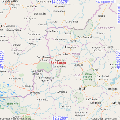
| Upper-left | 14.09675°, | -87.31423° |
| Center: | 13.4138°, | -86.6111° |
| Lower-right: | 12.7289°, | -85.90798° |
| Map W x H: | 152.1×152.1 km | = 94.5×94.5mi |
| max Lat: | 14.74189° ⇑16.2% North |
| San Lucas: | 13.4138° |
| min Lat: | ⇓83.8% South 10.94684° |
| min Long | San Lucas | max Long |
| -87.4516° | -86.6111° | -83.06145° |
| W 15.6%⇐ | ⇒84.4% E |
Elevation
Elevation of San Lucas is 789 m = 2589 ft, and this is 451.8 m = 1482 ft above average elevation for this country.
| Max E: |
1288 m = 4226 ft | 7.8% |
| San Lucas | 789 m 2589 ft | |
| Avg. | 337.2 m = 1106 ft | |
Min E: |
1 m = 3 ft | 92.2% |
See also: Nicaragua elevation on elevation.city.
Geographical zone
San Lucas is located in North Torrid zone (between Equator and Tropic of Cancer). Distance of this Northern Tropic circle is 1114.4 km =692.5 mi to North.| Distance of | km | miles | from San Lucas |
|---|---|---|---|
| North Pole | 8515.6 | 5291.3 | to North |
| Arctic Circle | 5909.7 | 3672.1 | to North |
| Tropic Cancer | 1114.4 | 692.5 | to North |
| Equator | 1491.5 | 926.8 | to South |


Nearby cities:
15 places around San Lucas: (largest is in red/bold)
• Cinco Pinos
34.5 km =21.4 mi,  233°
233°
• Condega
23.6 km =14.7 mi,  103°
103°
• Las Sabanas
8 km =5 mi,  188°
188°
• Macuelizo
26.6 km =16.5 mi,  359°
359°
• Mozonte
33.2 km =20.6 mi,  34°
34°
• Ocotal
28.4 km =17.6 mi, 31°
• Palacagüina
22.6 km =14 mi,  78°
78°
• Pueblo Nuevo
14.6 km =9.1 mi, 104°
• San Francisco del Norte
29.5 km =18.3 mi,  215°
215°
• San José de Cusmapa
14.7 km =9.1 mi,  198°
198°
• San Juan de Limay
26.4 km =16.4 mi,  180°
180°
• San Pedro del Norte
32.7 km =20.3 mi,  242°
242°
• Somoto
8.1 km =5 mi,  22°
22°
• Totogalpa
21 km =13 mi,  37°
37°
• Yalagüina
15 km =9.3 mi,  58°
58°
Sources, notices
• [Note1] Compared only with cities in Nicaragua existing in our database
• [Src1] Map data: © OpenStreetMap contributors (CC-BY-SA)
• [Src2] Other city data from geonames.org with taken over terms of usage.
• [Src3] Geographical zone / Annual Mean Temperature by Robert A. Rohde @ Wikipedia
