Totogalpa geodata
Totogalpa (Madriz) is a seat of a second-order administrative division; located in Nicaragua in America/Managua (GMT-6) time zone. With population of 2,265 people, there are 104 cities with bigger population in this country. Compared to other cities in Nicaragua, 88.6% of cities are located further ↓South; 78.4% of cities are located further →East and 87.4% of cities have lower elevation than Totogalpa. Note1


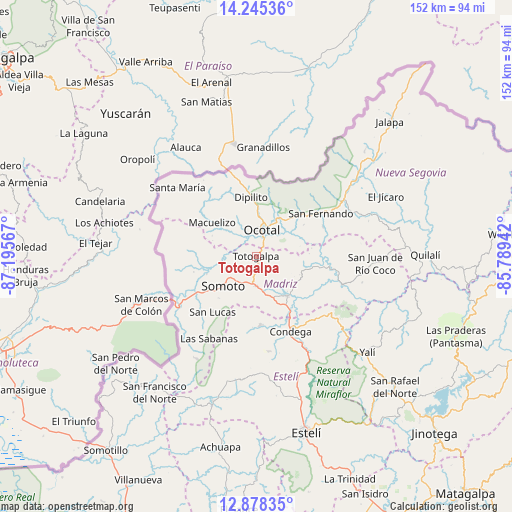
Totogalpa GPS coordinates[2]
13° 33' 46.224" North, 86° 29' 33.144" West
| Map corner | latitude | longitude |
|---|---|---|
| Upper-left | 14.24536°, | -87.19567° |
| Center: | 13.56284°, | -86.49254° |
| Lower-right: | 12.87835°, | -85.78942° |
| Map W x H: | 152×152 km | = 94.4×94.4mi |
| max Lat: | 14.74189° ⇑11.4% North |
| Totogalpa: | 13.56284° |
| min Lat: | ⇓88.6% South 10.94684° |
| min Long | Totogalpa | max Long |
| -87.4516° | -86.49254° | -83.06145° |
| W 21.6%⇐ | ⇒78.4% E |
Elevation
Elevation of Totogalpa is 690 m = 2264 ft, and this is 352.8 m = 1157 ft above average elevation for this country.
| Max E: |
1288 m = 4226 ft | 12.6% |
| Totogalpa | 690 m 2264 ft | |
| Avg. | 337.2 m = 1106 ft | |
Min E: |
1 m = 3 ft | 87.4% |
See also: Nicaragua elevation on elevation.city.
Geographical zone
Totogalpa is located in North Torrid zone (between Equator and Tropic of Cancer). Distance of this Northern Tropic circle is 1097.9 km =682.2 mi to North.| Distance of | km | miles | from Totogalpa |
|---|---|---|---|
| North Pole | 8499 | 5281 | to North |
| Arctic Circle | 5893.1 | 3661.8 | to North |
| Tropic Cancer | 1097.9 | 682.2 | to North |
| Equator | 1508 | 937 | to South |


Nearby cities:
15 places around Totogalpa: (largest is in red/bold)
• Ciudad Antigua
21.7 km =13.5 mi,  66°
66°
• Condega
24.2 km =15 mi,  155°
155°
• Dipilto
17.7 km =11 mi,  355°
355°
• Las Sabanas
28.2 km =17.5 mi,  209°
209°
• Macuelizo
16.4 km =10.2 mi,  307°
307°
• Mozonte
12.3 km =7.6 mi,  28°
28°
• Ocotal
7.9 km =4.9 mi,  13°
13°
• Palacagüina
15.1 km =9.4 mi,  141°
141°
• Pueblo Nuevo
20.4 km =12.7 mi,  176°
176°
• San Fernando
23.1 km =14.4 mi,  56°
56°
• San Lucas
21 km =13 mi,  217°
217°
• Santa María
31.1 km =19.3 mi, 311°
• Somoto
13.3 km =8.3 mi,  226°
226°
• Telpaneca
22.5 km =14 mi,  98°
98°
• Yalagüina
8.8 km =5.5 mi, 180°
Sources, notices
• [Note1] Compared only with cities in Nicaragua existing in our database
• [Src1] Map data: © OpenStreetMap contributors (CC-BY-SA)
• [Src2] Other city data from geonames.org with taken over terms of usage.
• [Src3] Geographical zone / Annual Mean Temperature by Robert A. Rohde @ Wikipedia
