La Paz Centro geodata
La Paz Centro (León) is a seat of a second-order administrative division; located in Nicaragua in America/Managua (GMT-6) time zone. With population of 23,481 people, there are 24 cities with bigger population in this country. Compared to other cities in Nicaragua, 59.9% of cities are located further ↑North; 87.4% of cities are located further →East and 75.4% of cities have higher elevation than La Paz Centro. Note1


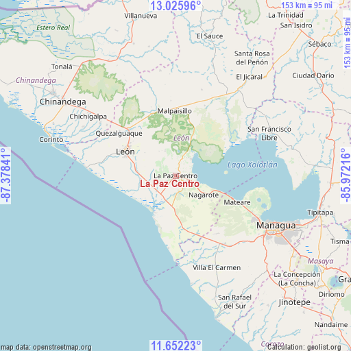
La Paz Centro GPS coordinates[2]
12° 20' 24" North, 86° 40' 31.008" West
| Map corner | latitude | longitude |
|---|---|---|
| Upper-left | 13.02596°, | -87.37841° |
| Center: | 12.34°, | -86.67528° |
| Lower-right: | 11.65223°, | -85.97216° |
| Map W x H: | 152.7×152.7 km | = 94.9×94.9mi |
| max Lat: | 14.74189° ⇑59.9% North |
| La Paz Centro: | 12.34° |
| min Lat: | ⇓40.1% South 10.94684° |
| min Long | La Paz Centro | max Long |
| -87.4516° | -86.67528° | -83.06145° |
| W 12.6%⇐ | ⇒87.4% E |
Elevation
Elevation of La Paz Centro is 73 m = 240 ft, and this is 264.2 m = 867 ft below average elevation for this country.
| Max E: |
1288 m = 4226 ft | 75.4% |
| Avg. | 337.2 m = 1106 ft | |
| La Paz Centro | 73 m = 240 ft | |
Min E: |
1 m = 3 ft | 24.6% |
See also: Nicaragua elevation on elevation.city.
Geographical zone
La Paz Centro is located in North Torrid zone (between Equator and Tropic of Cancer). Distance of this Northern Tropic circle is 1233.8 km =766.6 mi to North.| Distance of | km | miles | from La Paz Centro |
|---|---|---|---|
| North Pole | 8635 | 5365.5 | to North |
| Arctic Circle | 6029.1 | 3746.3 | to North |
| Tropic Cancer | 1233.8 | 766.6 | to North |
| Equator | 1372.1 | 852.6 | to South |


Nearby cities:
15 places around La Paz Centro: (largest is in red/bold)
• Chichigalpa
46.4 km =28.8 mi,  304°
304°
• Ciudad Sandino
41.2 km =25.6 mi,  119°
119°
• El Jicaral
53.6 km =33.3 mi,  36°
36°
• Larreynaga
39.1 km =24.3 mi,  16°
16°
• León
24.6 km =15.3 mi, 296°
• Malpaisillo
28.2 km =17.5 mi,  359°
359°
• Managua
51.6 km =32.1 mi, 116°
• Mateare
29.3 km =18.2 mi,  113°
113°
• Nagarote
14.6 km =9.1 mi, 124°
• Posoltega
40.1 km =24.9 mi, 304°
• Quezalguaque
30.9 km =19.2 mi,  306°
306°
• San Francisco Libre
44.7 km =27.8 mi,  65°
65°
• Telica
28.4 km =17.6 mi,  315°
315°
• Valle San Francisco
46.9 km =29.1 mi, 65°
• Villa El Carmen
44.1 km =27.4 mi,  155°
155°
Sources, notices
• [Note1] Compared only with cities in Nicaragua existing in our database
• [Src1] Map data: © OpenStreetMap contributors (CC-BY-SA)
• [Src2] Other city data from geonames.org with taken over terms of usage.
• [Src3] Geographical zone / Annual Mean Temperature by Robert A. Rohde @ Wikipedia
