Malpaisillo geodata
Malpaisillo (León) is a seat of a second-order administrative division; located in Nicaragua in America/Managua (GMT-6) time zone. In our database, there are 137 cities with bigger population. Compared to other cities in Nicaragua, 50.3% of cities are located further ↓South; 88% of cities are located further →East and 65.3% of cities have higher elevation than Malpaisillo. Note1


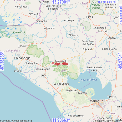
Malpaisillo GPS coordinates[2]
12° 35' 37.464" North, 86° 40' 46.272" West
| Map corner | latitude | longitude |
|---|---|---|
| Upper-left | 13.27901°, | -87.38265° |
| Center: | 12.59374°, | -86.67952° |
| Lower-right: | 11.90663°, | -85.9764° |
| Map W x H: | 152.6×152.6 km | = 94.8×94.8mi |
| max Lat: | 14.74189° ⇑49.7% North |
| Malpaisillo: | 12.59374° |
| min Lat: | ⇓50.3% South 10.94684° |
| min Long | Malpaisillo | max Long |
| -87.4516° | -86.67952° | -83.06145° |
| W 12%⇐ | ⇒88% E |
Elevation
Elevation of Malpaisillo is 119 m = 390 ft, and this is 218.2 m = 716 ft below average elevation for this country.
| Max E: |
1288 m = 4226 ft | 65.3% |
| Avg. | 337.2 m = 1106 ft | |
| Malpaisillo | 119 m = 390 ft | |
Min E: |
1 m = 3 ft | 34.7% |
See also: Nicaragua elevation on elevation.city.
Geographical zone
Malpaisillo is located in North Torrid zone (between Equator and Tropic of Cancer). Distance of this Northern Tropic circle is 1205.6 km =749.1 mi to North.| Distance of | km | miles | from Malpaisillo |
|---|---|---|---|
| North Pole | 8606.8 | 5348 | to North |
| Arctic Circle | 6000.9 | 3728.8 | to North |
| Tropic Cancer | 1205.6 | 749.1 | to North |
| Equator | 1400.3 | 870.1 | to South |


Nearby cities:
15 places around Malpaisillo: (largest is in red/bold)
• Chichigalpa
37.8 km =23.5 mi,  267°
267°
• El Jicaral
35.6 km =22.1 mi,  65°
65°
• El Sauce
36 km =22.4 mi,  25°
25°
• La Paz Centro
28.2 km =17.5 mi,  179°
179°
• Larreynaga
14.9 km =9.3 mi,  51°
51°
• León
27.7 km =17.2 mi,  231°
231°
• Mateare
48.3 km =30 mi,  145°
145°
• Nagarote
38.5 km =23.9 mi,  161°
161°
• Posoltega
33.1 km =20.6 mi,  260°
260°
• Quezalguaque
26.1 km =16.2 mi,  248°
248°
• San Francisco Libre
42.4 km =26.3 mi,  103°
103°
• Santa Rosa del Peñón
40.7 km =25.3 mi,  55°
55°
• Telica
21.1 km =13.1 mi, 247°
• Valle San Francisco
43.8 km =27.2 mi, 101°
• Villanueva
43.7 km =27.2 mi,  340°
340°
Sources, notices
• [Note1] Compared only with cities in Nicaragua existing in our database
• [Src1] Map data: © OpenStreetMap contributors (CC-BY-SA)
• [Src2] Other city data from geonames.org with taken over terms of usage.
• [Src3] Geographical zone / Annual Mean Temperature by Robert A. Rohde @ Wikipedia
