Kommerzijl geodata
Kommerzijl (Groningen) is a populated place; located in Netherlands in Europe/Amsterdam (GMT+2) time zone. With population of 510 people, there are 1827 cities with bigger population in this country. Compared to other cities in Netherlands, 97.1% of cities are located further ↓South; 86% of cities are located further ←West and 96.1% of cities have higher elevation than Kommerzijl. Note1


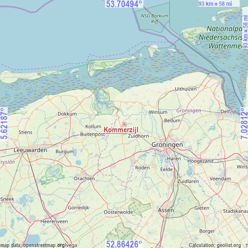
Kommerzijl GPS coordinates[2]
53° 17' 12.012" North, 6° 19' 30" East
| Map corner | latitude | longitude |
|---|---|---|
| Upper-left | 53.70494°, | 5.62187° |
| Center: | 53.28667°, | 6.325° |
| Lower-right: | 52.86426°, | 7.02812° |
| Map W x H: | 93.5×93.5 km | = 58.1×58.1mi |
| max Lat: | 53.48025° ⇑2.9% North |
| Kommerzijl: | 53.28667° |
| min Lat: | ⇓97.1% South 50.76917° |
| min Long | Kommerzijl | max Long |
| 3.38611° | 6.325° | 7.16528° |
| W 86%⇐ | ⇒14% E |
Elevation
Elevation of Kommerzijl is -1 m = -3 ft, and this is 16 m = 52 ft below average elevation for this country.
| Max E: |
203 m = 666 ft | 96.1% |
| Avg. | 15 m = 49 ft | |
| Kommerzijl | -1 m = -3 ft | |
Min E: |
-6 m = -20 ft | 3.9% |
See also: Netherlands elevation on elevation.city.
Geographical zone
Kommerzijl is located in North temperate zone (between Tropic of Cancer and the Arctic Circle). Distance of this North polar circle is 1476.3 km =917.3 mi to North.| Distance of | km | miles | from Kommerzijl |
|---|---|---|---|
| North Pole | 4082.1 | 2536.5 | to North |
| Arctic Circle | 1476.3 | 917.3 | to North |
| Tropic Cancer | 3319 | 2062.3 | to South |
| Equator | 5924.9 | 3681.6 | to South |


Nearby cities:
15 places around Kommerzijl: (largest is in red/bold)
• Aduard
9.6 km =6 mi,  110°
110°
• Burum
6.5 km =4 mi,  256°
256°
• Ezinge
8.2 km =5.1 mi,  71°
71°
• Gerkesklooster
9.7 km =6 mi,  236°
236°
• Grijpskerk
2.9 km =1.8 mi,  202°
202°
• Grootegast
8.9 km =5.5 mi, 202°
• Leens
8.9 km =5.5 mi,  23°
23°
• Lutjegast
7.3 km =4.5 mi,  217°
217°
• Niekerk
7.1 km =4.4 mi,  164°
164°
• Noordhorn
5.5 km =3.4 mi,  120°
120°
• Oldehove
5.1 km =3.2 mi, 68°
• Oldekerk
7.6 km =4.7 mi,  172°
172°
• Ulrum
8.1 km =5 mi,  3°
3°
• Zoutkamp
6 km =3.7 mi,  346°
346°
• Zuidhorn
6.8 km =4.2 mi,  130°
130°
Sources, notices
• [Note1] Compared only with cities in Netherlands existing in our database
• [Src1] Map data: © OpenStreetMap contributors (CC-BY-SA)
• [Src2] Other city data from geonames.org with taken over terms of usage.
• [Src3] Geographical zone / Annual Mean Temperature by Robert A. Rohde @ Wikipedia
