Harlingen geodata
Harlingen (Friesland) is a populated place; located in Netherlands in Europe/Amsterdam (GMT+2) time zone. With population of 16,119 people, there are 216 cities with bigger population in this country. Compared to other cities in Netherlands, 92% of cities are located further ↓South; 59.6% of cities are located further →East and 65.8% of cities have higher elevation than Harlingen. Note1


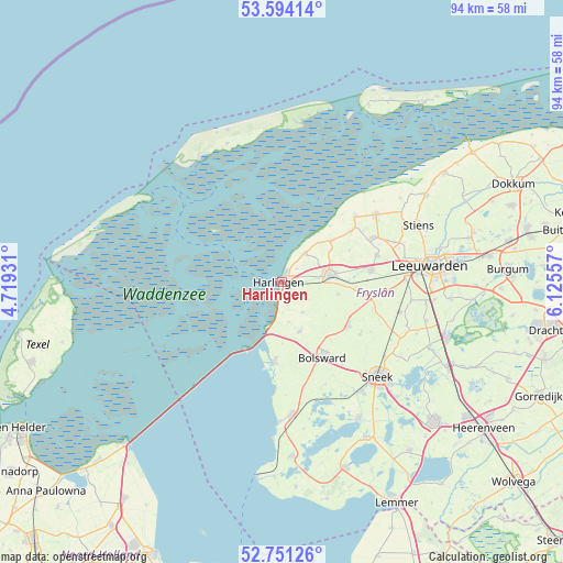
Harlingen GPS coordinates[2]
53° 10' 29.172" North, 5° 25' 20.784" East
| Map corner | latitude | longitude |
|---|---|---|
| Upper-left | 53.59414°, | 4.71931° |
| Center: | 53.17477°, | 5.42244° |
| Lower-right: | 52.75126°, | 6.12557° |
| Map W x H: | 93.7×93.7 km | = 58.2×58.2mi |
| max Lat: | 53.48025° ⇑8% North |
| Harlingen: | 53.17477° |
| min Lat: | ⇓92% South 50.76917° |
| min Long | Harlingen | max Long |
| 3.38611° | 5.42244° | 7.16528° |
| W 40.4%⇐ | ⇒59.6% E |
Elevation
Elevation of Harlingen is 3 m = 10 ft, and this is 12 m = 39 ft below average elevation for this country.
| Max E: |
203 m = 666 ft | 65.8% |
| Avg. | 15 m = 49 ft | |
| Harlingen | 3 m = 10 ft | |
Min E: |
-6 m = -20 ft | 34.2% |
See also: Netherlands elevation on elevation.city.
Geographical zone
Harlingen is located in North temperate zone (between Tropic of Cancer and the Arctic Circle). Distance of this North polar circle is 1488.7 km =925 mi to North.| Distance of | km | miles | from Harlingen |
|---|---|---|---|
| North Pole | 4094.6 | 2544.3 | to North |
| Arctic Circle | 1488.7 | 925 | to North |
| Tropic Cancer | 3306.6 | 2054.6 | to South |
| Equator | 5912.5 | 3673.9 | to South |


Nearby cities:
15 places around Harlingen: (largest is in red/bold)
• Achlum
5 km =3.1 mi,  124°
124°
• Arum
6.2 km =3.9 mi,  144°
144°
• Bolsward
14.2 km =8.8 mi,  149°
149°
• Dronryp
15.4 km =9.6 mi,  79°
79°
• Franeker
8 km =5 mi, 81°
• Makkum
13.4 km =8.3 mi,  185°
185°
• Midlum
1.9 km =1.2 mi,  65°
65°
• Minnertsga
14.3 km =8.9 mi,  53°
53°
• Sexbierum
6.3 km =3.9 mi,  40°
40°
• Sint Jacobiparochie
16.3 km =10.1 mi, 47°
• Tzum
9.5 km =5.9 mi,  100°
100°
• Tzummarum
10.8 km =6.7 mi, 49°
• Winsum
14.3 km =8.9 mi, 100°
• Witmarsum
8.4 km =5.2 mi,  158°
158°
• Wommels
13.2 km =8.2 mi, 123°
Sources, notices
• [Note1] Compared only with cities in Netherlands existing in our database
• [Src1] Map data: © OpenStreetMap contributors (CC-BY-SA)
• [Src2] Other city data from geonames.org with taken over terms of usage.
• [Src3] Geographical zone / Annual Mean Temperature by Robert A. Rohde @ Wikipedia
