Wijk aan Zee geodata
Wijk aan Zee (North Holland) is a populated place; located in Netherlands in Europe/Amsterdam (GMT+2) time zone. With population of 2,095 people, there are 934 cities with bigger population in this country. Compared to other cities in Netherlands, 71.3% of cities are located further ↓South; 86.6% of cities are located further →East and 57.3% of cities have lower elevation than Wijk aan Zee. Note1


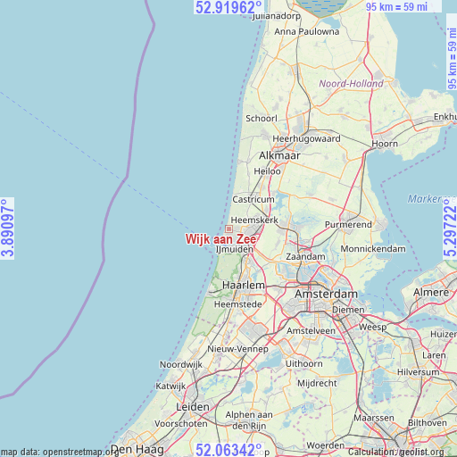
Wijk aan Zee GPS coordinates[2]
52° 29' 36.96" North, 4° 35' 38.724" East
| Map corner | latitude | longitude |
|---|---|---|
| Upper-left | 52.91962°, | 3.89097° |
| Center: | 52.4936°, | 4.59409° |
| Lower-right: | 52.06342°, | 5.29722° |
| Map W x H: | 95.2×95.2 km | = 59.2×59.2mi |
| max Lat: | 53.48025° ⇑28.7% North |
| Wijk aan Zee: | 52.4936° |
| min Lat: | ⇓71.3% South 50.76917° |
| min Long | Wijk aan Zee | max Long |
| 3.38611° | 4.59409° | 7.16528° |
| W 13.4%⇐ | ⇒86.6% E |
Elevation
Elevation of Wijk aan Zee is 9 m = 30 ft, and this is 6 m = 20 ft below average elevation for this country.
| Max E: |
203 m = 666 ft | 42.7% |
| Avg. | 15 m = 49 ft | |
| Wijk aan Zee | 9 m = 30 ft | |
Min E: |
-6 m = -20 ft | 57.3% |
See also: Netherlands elevation on elevation.city.
Geographical zone
Wijk aan Zee is located in North temperate zone (between Tropic of Cancer and the Arctic Circle). Distance of this North polar circle is 1564.4 km =972.1 mi to North.| Distance of | km | miles | from Wijk aan Zee |
|---|---|---|---|
| North Pole | 4170.3 | 2591.3 | to North |
| Arctic Circle | 1564.4 | 972.1 | to North |
| Tropic Cancer | 3230.8 | 2007.5 | to South |
| Equator | 5836.7 | 3626.8 | to South |


Nearby cities:
15 places around Wijk aan Zee: (largest is in red/bold)
• Beverwijk
4.4 km =2.7 mi,  105°
105°
• Bloemendaal
10.3 km =6.4 mi,  169°
169°
• Castricum
7.9 km =4.9 mi,  39°
39°
• Commandeurs
4.7 km =2.9 mi,  68°
68°
• De Maer
6.6 km =4.1 mi,  64°
64°
• Egmond-Binnen
12.1 km =7.5 mi,  20°
20°
• Heemskerk
5.6 km =3.5 mi, 69°
• Heemskerkerduin
3 km =1.9 mi, 58°
• Hofgeest
7.1 km =4.4 mi,  142°
142°
• Langeheit
11.1 km =6.9 mi,  90°
90°
• Limmen
10.8 km =6.7 mi, 38°
• Overveen
11.4 km =7.1 mi, 173°
• Uitgeest
8.8 km =5.5 mi, 63°
• Velsen-Zuid
5.3 km =3.3 mi,  134°
134°
• Waterakkers
4.4 km =2.7 mi, 74°
Sources, notices
• [Note1] Compared only with cities in Netherlands existing in our database
• [Src1] Map data: © OpenStreetMap contributors (CC-BY-SA)
• [Src2] Other city data from geonames.org with taken over terms of usage.
• [Src3] Geographical zone / Annual Mean Temperature by Robert A. Rohde @ Wikipedia
