Langeheit geodata
Langeheit (North Holland) is a populated place; located in Netherlands in Europe/Amsterdam (GMT+2) time zone. With population of 1,180 people, there are 1293 cities with bigger population in this country. Compared to other cities in Netherlands, 71.2% of cities are located further ↓South; 81.4% of cities are located further →East and 91.3% of cities have higher elevation than Langeheit. Note1


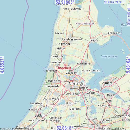
Langeheit GPS coordinates[2]
52° 29' 31.2" North, 4° 45' 30.564" East
| Map corner | latitude | longitude |
|---|---|---|
| Upper-left | 52.91803°, | 4.05537° |
| Center: | 52.492°, | 4.75849° |
| Lower-right: | 52.0618°, | 5.46162° |
| Map W x H: | 95.2×95.2 km | = 59.2×59.2mi |
| max Lat: | 53.48025° ⇑28.8% North |
| Langeheit: | 52.492° |
| min Lat: | ⇓71.2% South 50.76917° |
| min Long | Langeheit | max Long |
| 3.38611° | 4.75849° | 7.16528° |
| W 18.6%⇐ | ⇒81.4% E |
Elevation
Elevation of Langeheit is 0 m = 0 ft, and this is 15 m = 49 ft below average elevation for this country.
| Max E: |
203 m = 666 ft | 91.3% |
| Avg. | 15 m = 49 ft | |
| Langeheit | 0 m = 0 ft | |
Min E: |
-6 m = -20 ft | 8.7% |
See also: Netherlands elevation on elevation.city.
Geographical zone
Langeheit is located in North temperate zone (between Tropic of Cancer and the Arctic Circle). Distance of this North polar circle is 1564.6 km =972.2 mi to North.| Distance of | km | miles | from Langeheit |
|---|---|---|---|
| North Pole | 4170.5 | 2591.4 | to North |
| Arctic Circle | 1564.6 | 972.2 | to North |
| Tropic Cancer | 3230.6 | 2007.4 | to South |
| Equator | 5836.6 | 3626.7 | to South |


Nearby cities:
15 places around Langeheit: (largest is in red/bold)
• Beverwijk
6.9 km =4.3 mi,  262°
262°
• Castricum
8.7 km =5.4 mi,  316°
316°
• Commandeurs
7 km =4.3 mi,  285°
285°
• De Maer
6 km =3.7 mi,  300°
300°
• Heemskerk
6.2 km =3.9 mi, 289°
• Heemskerkerduin
8.7 km =5.4 mi,  281°
281°
• Hofgeest
8.7 km =5.4 mi,  231°
231°
• Oostknollendam
3.6 km =2.2 mi,  38°
38°
• Uitgeest
5.3 km =3.3 mi, 321°
• Velsen-Zuid
8.2 km =5.1 mi,  244°
244°
• Waterakkers
7.1 km =4.4 mi, 281°
• West-Graftdijk
7.4 km =4.6 mi,  20°
20°
• Zaandam
7.5 km =4.7 mi,  142°
142°
• Zaandijk
3.8 km =2.4 mi,  120°
120°
• Zaanstad
5.7 km =3.5 mi, 139°
Sources, notices
• [Note1] Compared only with cities in Netherlands existing in our database
• [Src1] Map data: © OpenStreetMap contributors (CC-BY-SA)
• [Src2] Other city data from geonames.org with taken over terms of usage.
• [Src3] Geographical zone / Annual Mean Temperature by Robert A. Rohde @ Wikipedia
