Bloemendaal geodata
Bloemendaal (North Holland) is a populated place; located in Netherlands in Europe/Amsterdam (GMT+2) time zone. With population of 3,905 people, there are 601 cities with bigger population in this country. Compared to other cities in Netherlands, 69.1% of cities are located further ↓South; 85.8% of cities are located further →East and 58.8% of cities have higher elevation than Bloemendaal. Note1


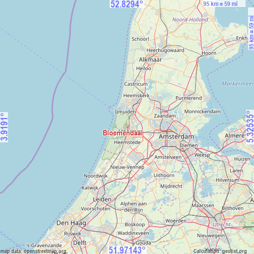
Bloemendaal GPS coordinates[2]
52° 24' 9" North, 4° 37' 19.992" East
| Map corner | latitude | longitude |
|---|---|---|
| Upper-left | 52.8294°, | 3.9191° |
| Center: | 52.4025°, | 4.62222° |
| Lower-right: | 51.97143°, | 5.32535° |
| Map W x H: | 95.4×95.4 km | = 59.3×59.3mi |
| max Lat: | 53.48025° ⇑30.9% North |
| Bloemendaal: | 52.4025° |
| min Lat: | ⇓69.1% South 50.76917° |
| min Long | Bloemendaal | max Long |
| 3.38611° | 4.62222° | 7.16528° |
| W 14.2%⇐ | ⇒85.8% E |
Elevation
Elevation of Bloemendaal is 4 m = 13 ft, and this is 11 m = 36 ft below average elevation for this country.
| Max E: |
203 m = 666 ft | 58.8% |
| Avg. | 15 m = 49 ft | |
| Bloemendaal | 4 m = 13 ft | |
Min E: |
-6 m = -20 ft | 41.2% |
See also: Netherlands elevation on elevation.city.
Geographical zone
Bloemendaal is located in North temperate zone (between Tropic of Cancer and the Arctic Circle). Distance of this North polar circle is 1574.6 km =978.4 mi to North.| Distance of | km | miles | from Bloemendaal |
|---|---|---|---|
| North Pole | 4180.5 | 2597.6 | to North |
| Arctic Circle | 1574.6 | 978.4 | to North |
| Tropic Cancer | 3220.7 | 2001.2 | to South |
| Equator | 5826.6 | 3620.5 | to South |


Nearby cities:
15 places around Bloemendaal: (largest is in red/bold)
• Bennebroek
9.2 km =5.7 mi,  190°
190°
• Beverwijk
9.3 km =5.8 mi,  14°
14°
• Cruquius
7.5 km =4.7 mi,  173°
173°
• De Glip
8 km =5 mi, 185°
• Haarlem
2.6 km =1.6 mi,  157°
157°
• Halfweg
9.2 km =5.7 mi,  103°
103°
• Heemstede
5.8 km =3.6 mi,  179°
179°
• Hofgeest
5.2 km =3.2 mi,  28°
28°
• Overveen
1.3 km =0.8 mi,  205°
205°
• Velsen-Zuid
6.7 km =4.2 mi,  16°
16°
• Vijfhuizen
6.9 km =4.3 mi,  146°
146°
• Vogelenzang
9.7 km =6 mi,  198°
198°
• Wijk aan Zee
10.3 km =6.4 mi,  349°
349°
• Zandvoort
7 km =4.3 mi,  240°
240°
• Zwaanshoek
10 km =6.2 mi, 182°
Sources, notices
• [Note1] Compared only with cities in Netherlands existing in our database
• [Src1] Map data: © OpenStreetMap contributors (CC-BY-SA)
• [Src2] Other city data from geonames.org with taken over terms of usage.
• [Src3] Geographical zone / Annual Mean Temperature by Robert A. Rohde @ Wikipedia
