Velsen-Zuid geodata
Velsen-Zuid (North Holland) is a populated place; located in Netherlands in Europe/Amsterdam (GMT+2) time zone. With population of 67,758 people, there are 46 cities with bigger population in this country. Compared to other cities in Netherlands, 70.5% of cities are located further ↓South; 85% of cities are located further →East and 58.8% of cities have higher elevation than Velsen-Zuid. Note1


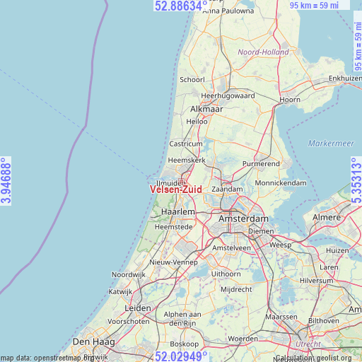
Velsen-Zuid GPS coordinates[2]
52° 27' 36" North, 4° 39' 0" East
| Map corner | latitude | longitude |
|---|---|---|
| Upper-left | 52.88634°, | 3.94688° |
| Center: | 52.46°, | 4.65° |
| Lower-right: | 52.02949°, | 5.35313° |
| Map W x H: | 95.3×95.3 km | = 59.2×59.2mi |
| max Lat: | 53.48025° ⇑29.5% North |
| Velsen-Zuid: | 52.46° |
| min Lat: | ⇓70.5% South 50.76917° |
| min Long | Velsen-Zuid | max Long |
| 3.38611° | 4.65° | 7.16528° |
| W 15%⇐ | ⇒85% E |
Elevation
Elevation of Velsen-Zuid is 4 m = 13 ft, and this is 11 m = 36 ft below average elevation for this country.
| Max E: |
203 m = 666 ft | 58.8% |
| Avg. | 15 m = 49 ft | |
| Velsen-Zuid | 4 m = 13 ft | |
Min E: |
-6 m = -20 ft | 41.2% |
See also: Velsen-Zuid elevation on elevation.city.
Geographical zone
Velsen-Zuid is located in North temperate zone (between Tropic of Cancer and the Arctic Circle). Distance of this North polar circle is 1568.2 km =974.4 mi to North.| Distance of | km | miles | from Velsen-Zuid |
|---|---|---|---|
| North Pole | 4174.1 | 2593.7 | to North |
| Arctic Circle | 1568.2 | 974.4 | to North |
| Tropic Cancer | 3227.1 | 2005.2 | to South |
| Equator | 5833 | 3624.5 | to South |


Nearby cities:
15 places around Velsen-Zuid: (largest is in red/bold)
• Beverwijk
2.6 km =1.6 mi,  10°
10°
• Bloemendaal
6.7 km =4.2 mi,  196°
196°
• Castricum
9.9 km =6.2 mi, 7°
• Commandeurs
5.5 km =3.4 mi, 5°
• De Maer
6.9 km =4.3 mi,  18°
18°
• Haarlem
8.8 km =5.5 mi,  185°
185°
• Heemskerk
5.9 km =3.7 mi, 14°
• Heemskerkerduin
5.4 km =3.4 mi,  346°
346°
• Hofgeest
1.9 km =1.2 mi,  163°
163°
• Langeheit
8.2 km =5.1 mi,  64°
64°
• Overveen
8 km =5 mi, 197°
• Uitgeest
8.7 km =5.4 mi,  27°
27°
• Waterakkers
5 km =3.1 mi,  4°
4°
• Wijk aan Zee
5.3 km =3.3 mi,  314°
314°
• Zaandijk
10.8 km =6.7 mi,  81°
81°
Sources, notices
• [Note1] Compared only with cities in Netherlands existing in our database
• [Src1] Map data: © OpenStreetMap contributors (CC-BY-SA)
• [Src2] Other city data from geonames.org with taken over terms of usage.
• [Src3] Geographical zone / Annual Mean Temperature by Robert A. Rohde @ Wikipedia
