Beverwijk geodata
Beverwijk (North Holland) is a populated place; located in Netherlands in Europe/Amsterdam (GMT+2) time zone. With population of 37,585 people, there are 86 cities with bigger population in this country. Compared to other cities in Netherlands, 71.1% of cities are located further ↓South; 84.4% of cities are located further →East and 65.8% of cities have higher elevation than Beverwijk. Note1


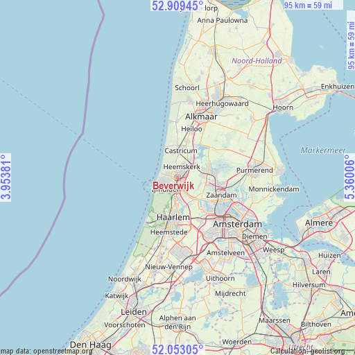
Beverwijk GPS coordinates[2]
52° 28' 59.988" North, 4° 39' 24.984" East
| Map corner | latitude | longitude |
|---|---|---|
| Upper-left | 52.90945°, | 3.95381° |
| Center: | 52.48333°, | 4.65694° |
| Lower-right: | 52.05305°, | 5.36006° |
| Map W x H: | 95.2×95.2 km | = 59.2×59.2mi |
| max Lat: | 53.48025° ⇑28.9% North |
| Beverwijk: | 52.48333° |
| min Lat: | ⇓71.1% South 50.76917° |
| min Long | Beverwijk | max Long |
| 3.38611° | 4.65694° | 7.16528° |
| W 15.6%⇐ | ⇒84.4% E |
Elevation
Elevation of Beverwijk is 3 m = 10 ft, and this is 12 m = 39 ft below average elevation for this country.
| Max E: |
203 m = 666 ft | 65.8% |
| Avg. | 15 m = 49 ft | |
| Beverwijk | 3 m = 10 ft | |
Min E: |
-6 m = -20 ft | 34.2% |
See also: Netherlands elevation on elevation.city.
Geographical zone
Beverwijk is located in North temperate zone (between Tropic of Cancer and the Arctic Circle). Distance of this North polar circle is 1565.6 km =972.8 mi to North.| Distance of | km | miles | from Beverwijk |
|---|---|---|---|
| North Pole | 4171.5 | 2592 | to North |
| Arctic Circle | 1565.6 | 972.8 | to North |
| Tropic Cancer | 3229.7 | 2006.8 | to South |
| Equator | 5835.6 | 3626.1 | to South |


Nearby cities:
15 places around Beverwijk: (largest is in red/bold)
• Bloemendaal
9.3 km =5.8 mi,  194°
194°
• Castricum
7.3 km =4.5 mi,  6°
6°
• Commandeurs
2.9 km =1.8 mi,  2°
2°
• De Maer
4.3 km =2.7 mi,  22°
22°
• Heemskerk
3.2 km =2 mi, 17°
• Heemskerkerduin
3.2 km =2 mi,  327°
327°
• Hofgeest
4.4 km =2.7 mi,  178°
178°
• Langeheit
6.9 km =4.3 mi,  82°
82°
• Limmen
9.9 km =6.2 mi, 14°
• Oostknollendam
9.9 km =6.2 mi,  67°
67°
• Uitgeest
6.2 km =3.9 mi,  35°
35°
• Velsen-Zuid
2.6 km =1.6 mi, 190°
• Waterakkers
2.3 km =1.4 mi,  358°
358°
• Wijk aan Zee
4.4 km =2.7 mi,  285°
285°
• Zaandijk
10.2 km =6.3 mi,  95°
95°
Sources, notices
• [Note1] Compared only with cities in Netherlands existing in our database
• [Src1] Map data: © OpenStreetMap contributors (CC-BY-SA)
• [Src2] Other city data from geonames.org with taken over terms of usage.
• [Src3] Geographical zone / Annual Mean Temperature by Robert A. Rohde @ Wikipedia
