Wieringerwerf geodata
Wieringerwerf (North Holland) is a populated place; located in Netherlands in Europe/Amsterdam (GMT+2) time zone. With population of 3,210 people, there are 723 cities with bigger population in this country. Compared to other cities in Netherlands, 81.4% of cities are located further ↓South; 72.7% of cities are located further →East and 99.9% of cities have higher elevation than Wieringerwerf. Note1


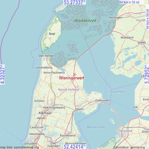
Wieringerwerf GPS coordinates[2]
52° 51' 2.988" North, 5° 1' 35.004" East
| Map corner | latitude | longitude |
|---|---|---|
| Upper-left | 53.27337°, | 4.32327° |
| Center: | 52.85083°, | 5.02639° |
| Lower-right: | 52.42414°, | 5.72952° |
| Map W x H: | 94.4×94.4 km | = 58.7×58.7mi |
| max Lat: | 53.48025° ⇑18.6% North |
| Wieringerwerf: | 52.85083° |
| min Lat: | ⇓81.4% South 50.76917° |
| min Long | Wieringerwerf | max Long |
| 3.38611° | 5.02639° | 7.16528° |
| W 27.3%⇐ | ⇒72.7% E |
Elevation
Elevation of Wieringerwerf is -4 m = -13 ft, and this is 19 m = 62 ft below average elevation for this country.
| Max E: |
203 m = 666 ft | 99.9% |
| Avg. | 15 m = 49 ft | |
| Wieringerwerf | -4 m = -13 ft | |
Min E: |
-6 m = -20 ft | 0.1% |
See also: Netherlands elevation on elevation.city.
Geographical zone
Wieringerwerf is located in North temperate zone (between Tropic of Cancer and the Arctic Circle). Distance of this North polar circle is 1524.7 km =947.4 mi to North.| Distance of | km | miles | from Wieringerwerf |
|---|---|---|---|
| North Pole | 4130.6 | 2566.6 | to North |
| Arctic Circle | 1524.7 | 947.4 | to North |
| Tropic Cancer | 3270.5 | 2032.2 | to South |
| Equator | 5876.5 | 3651.5 | to South |


Nearby cities:
15 places around Wieringerwerf: (largest is in red/bold)
• Abbekerk
13.3 km =8.3 mi,  182°
182°
• Barsingerhorn
13.1 km =8.1 mi,  236°
236°
• De Weere
14 km =8.7 mi,  188°
188°
• Den Oever
9.2 km =5.7 mi,  1°
1°
• Hippolytushoef
7.6 km =4.7 mi,  325°
325°
• Kolhorn
11.2 km =7 mi, 235°
• Kreileroord
3.9 km =2.4 mi,  105°
105°
• Medemblik
10.3 km =6.4 mi,  148°
148°
• Middenmeer
5.3 km =3.3 mi,  200°
200°
• Opperdoes
10.7 km =6.6 mi,  162°
162°
• Slootdorp
3.8 km =2.4 mi,  255°
255°
• Twisk
12.4 km =7.7 mi,  171°
171°
• Westerland
8.1 km =5 mi,  306°
306°
• Wieringerwaard
10.9 km =6.8 mi, 261°
• Winkel
13.6 km =8.5 mi,  217°
217°
Sources, notices
• [Note1] Compared only with cities in Netherlands existing in our database
• [Src1] Map data: © OpenStreetMap contributors (CC-BY-SA)
• [Src2] Other city data from geonames.org with taken over terms of usage.
• [Src3] Geographical zone / Annual Mean Temperature by Robert A. Rohde @ Wikipedia
